File:Faial - Cabeco Gordo - ISS002.JPG

Size of this preview: 800 × 532 pixels. Other resolutions: 320 × 213 pixels | 640 × 426 pixels | 1,024 × 681 pixels | 1,280 × 852 pixels | 3,060 × 2,036 pixels.
Original file (3,060 × 2,036 pixels, file size: 1.15 MB, MIME type: image/jpeg)
Captions
Captions
Add a one-line explanation of what this file represents
Summary
edit
| Description |
Deutsch: Die Ilha do Faial ist die fünftgrößte Insel der zu Portugal gehörenden Azoreninseln. Sie wird auch Ilha Azul (die blaue Insel) genannt, wegen der vielen blauen Hortensienhecken. Faial spielte von jeher eine besondere Rolle, ob als Zwischenstation der frühen Transatlantikflüge, ob als Zentrum für die Telekommunikation zwischen Europa und Amerika oder als wichtiger Yachthafen.
English: Faial Island ( pron. ), also known in English as Fayal, is a Portuguese island of the Central group (Grupo Central) of the Azores. Its area is 173 km² and it is located 28.7° W longitude and 38.6° N latitude. The nearest island is Pico Island to the east.
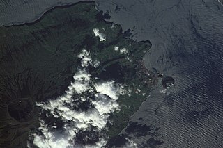
Southeast corner of Faial Island, with Cabeço Gordo volcano and town of Horta. Photographed from International Space Station. Español: Faial es la tercera isla más grande del archipiélago de las Azores, Portugal. Su capital es Horta.
Euskara: Faial Portugalgo Azoreak uhartediko irletako bat da, erdialdean kokatuta. Bertan Horta izeneko herri bakarra dago.
Français : Faial est une île portugaise faisant partie de l’archipel l’archipel des Açores. Sa surface est de 169,94 km², et elle compte 15 063 habitants. La ville principale de l’île est Horta. L’île la plus proche est Pico située à l’est. Le sommet de l’île est le Cabeço Gordo, qui culmine à 1 043 mètres d’altitude et surplombe une magnifique caldeira de 2 km de diamètre et 400 m de profondeur.
Nederlands: Faial (Ilha do Faial) is één van de eilanden van de Azoren. Met een vorm van een onregelmatige vijfhoek en een oppervlakte van 173,42 km², heeft het eiland Faial een lengte van 21 km en is op zijn breedste punt 14 km breed. Het eiland wordt gedomineerd door de vulkaan Caldeira. Het hoogste punt van het eiland is Cabeço Gordo met een hoogte van 1043 meter, op de rand van de Caldeira (Cabeço Gordo). Westelijk van deze oude vulkaan ligt een rij steeds kleinere vulkanen; de laatste uitbarsting is van 1957-1958, toen bij Capelinhos maandenlang vulkanische activiteit was die het toenmalige dorpje onder de as bedekte. Door de vulkaan uitbarsting is aan het westelijke deel van het eiland, bij het dorpje Capelo, is het eiland 2,4 km² groter geworden.
Português: Situada no extremo ocidental do Grupo Central do Arquipélago dos Açores, a Ilha do Faial está separado da Ilha do Pico por um estreito de 8,3 km (ou 4,5 milhas náuticas) de largura - o Canal do Faial. Tem uma área de 172,43 km² e uma população residente de 15 063 habitantes (em 2001). Em 1924, Raúl Brandão chamou-a de "Ilha Azul" devido à grande quantidade de hortênsias (localmente chamados de novelos) que florescem ao longo das estradas, nos meses de Verão. Dispõe de um moderno Aeroporto Internacional, com ligações aéreas regulares inter-ilhas e directas com Lisboa, bem como de diversas ligações maritímas inter-ilhas.
|
| Date | |
| Source | http://eol.jsc.nasa.gov/scripts/sseop/photo.pl?mission=ISS002&roll=E&frame=5675 |
| Author | Expedition 2 Crew Member |
| Permission (Reusing this file) |
PD-NASA |
| Camera location | | View this and other nearby images on: OpenStreetMap |
|---|
Notes:
- Identification as Cabeço Gordo and Horta based on http://www.oceandots.com/atlantic/azores/faial.htm
- Image has been rotated 180 degrees (compared to NASA source). North is in the direction of the upper left corner, based on map at [1]
- Image contrast auto-stretched using the Gimp
Licensing
edit
This file is in the public domain in the United States because it was created by the Image Science & Analysis Laboratory, of the NASA Johnson Space Center. NASA copyright policy states that "NASA material is not protected by copyright unless noted". (NASA media use guidelines or Conditions of Use of Astronaut Photographs).
Photo source: ISS002-E-5675.
|
File history
Click on a date/time to view the file as it appeared at that time.
| Date/Time | Thumbnail | Dimensions | User | Comment | |
|---|---|---|---|---|---|
| current | 22:48, 1 February 2007 | | 3,060 × 2,036 (1.15 MB) | Davepape (talk | contribs) | image rotated & contrast-stretched |
| 22:11, 1 February 2007 |  | 3,060 × 2,036 (1.04 MB) | Davepape (talk | contribs) | {{Information |Description={{w|Cabeço Gordo}} volcano, on {{w|Faial Island}}. Photographed from International Space Station. |Source=NASA/JSC Gateway to Astronaut Photography of Earth. http://eol.jsc.nasa.gov/scripts/sseop/photo.pl?mission=ISS002&roll=E |
You cannot overwrite this file.
File usage on Commons
There are no pages that use this file.