File:Fairbanks, Alaska ESA23840372.jpeg

Original file (10,644 × 10,644 pixels, file size: 26.7 MB, MIME type: image/jpeg)
Captions
Captions
Summary edit
| Warning | The original file is very high-resolution. It might not load properly or could cause your browser to freeze when opened at full size. |
|---|
| Description |
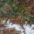
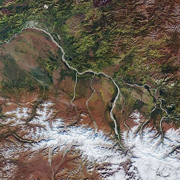
English: The city of Fairbanks, the largest city in the Interior region of Alaska, and its surroundings, are featured in this Copernicus Sentinel-2 image. Zoom in to see this image at its full 20 m resolution or click on the circles to learn more about the features in it. Visible in the top-left corner of the image, Fairbanks is located in the central Tanana Valley, straddling the Chena River near its confluence with the Tanana River – a 940 km tributary of the Yukon River. Dominating this week’s image, the Tanana River’s name is an Athabascan word meaning ‘river trail’. Many low streams and rivers flow into the Tanana River. The river flows in a northwest direction along the base of the Alaska Range (visible in the bottom of the image) before joining the Yukon River near the village of Tanana. The river drains the north slopes of the high Alaska Range and is fed by several glaciers. The sediment-laden Tanana is rich in minerals, which gives it its milky colour. South of the Tanana River lies the Tanana Flats, an area of marsh and bog that stretches for more than 160 km until it rises into the Alaska Range. One of the components of the Alaskan mountains, the Alaska Range extends for around 650 km in a generally east-west arc from the Aleutian Range to the boundary of Yukon. The mountain range can sometimes be seen from Fairbanks on clear days. The highest mountain in North America, the Denali, lies in the Alaska Range and reaches an elevation of over 6000 m (not visible). Around 20 km from Fairbanks lies the city of North Pole. Despite its name, the city is around 2700 km south of Earth’s geographic North Pole and around 200 km south of the Arctic Circle. Light green colours in the image indicate deciduous forest, while dark green represents evergreen forests. Sentinel-2 is a two-satellite mission to supply the coverage and data delivery needed for Europe’s Copernicus programme. The mission’s frequent revisits over the same area and high spatial resolution allow changes in both land and water bodies to be closely monitored. This image, captured on 11 September 2021, is also featured on the Earth from Space video programme. |
| Date | Taken on 11 September 2021 |
| Source | Fairbanks, Alaska |
| Author | European Space Agency |
| Other versions |
|
| Activity | Observing the Earth |
| Mission | Sentinel-2 |
| Set | Earth observation image of the week |
| System | Copernicus |
Licensing edit

|
This image contains data from a satellite in the Copernicus Programme, such as Sentinel-1, Sentinel-2 or Sentinel-3. Attribution is required when using this image.
Attribution: Contains modified Copernicus Sentinel data 2021
The use of Copernicus Sentinel Data is regulated under EU law (Commission Delegated Regulation (EU) No 1159/2013 and Regulation (EU) No 377/2014). Relevant excerpts:
Free access shall be given to GMES dedicated data [...] made available through GMES dissemination platforms [...].
Access to GMES dedicated data [...] shall be given for the purpose of the following use in so far as it is lawful:
GMES dedicated data [...] may be used worldwide without limitations in time.
GMES dedicated data and GMES service information are provided to users without any express or implied warranty, including as regards quality and suitability for any purpose. |
This media was created by the European Space Agency (ESA).
Where expressly so stated, images or videos are covered by the Creative Commons Attribution-ShareAlike 3.0 IGO (CC BY-SA 3.0 IGO) licence, ESA being an Intergovernmental Organisation (IGO), as defined by the CC BY-SA 3.0 IGO licence. The user is allowed under the terms and conditions of the CC BY-SA 3.0 IGO license to Reproduce, Distribute and Publicly Perform the ESA images and videos released under CC BY-SA 3.0 IGO licence and the Adaptations thereof, without further explicit permission being necessary, for as long as the user complies with the conditions and restrictions set forth in the CC BY-SA 3.0 IGO licence, these including that:
See the ESA Creative Commons copyright notice for complete information, and this article for additional details.
|
 | |
This file is licensed under the Creative Commons Attribution-ShareAlike 3.0 IGO license. Attribution: ESA, CC BY-SA IGO 3.0
| ||
File history
Click on a date/time to view the file as it appeared at that time.
| Date/Time | Thumbnail | Dimensions | User | Comment | |
|---|---|---|---|---|---|
| current | 10:02, 10 December 2021 | | 10,644 × 10,644 (26.7 MB) | OptimusPrimeBot (talk | contribs) | #Spacemedia - Upload of https://www.esa.int/var/esa/storage/images/esa_multimedia/images/2021/12/fairbanks_alaska/23840362-1-eng-GB/Fairbanks_Alaska.jpg via Commons:Spacemedia |
You cannot overwrite this file.
File usage on Commons
The following page uses this file: