File:Falk Oberdorf Karte Blasheimer Markt.png
Falk_Oberdorf_Karte_Blasheimer_Markt.png (800 × 550 pixels, file size: 121 KB, MIME type: image/png)
Captions
Captions
Summary edit
| Description |
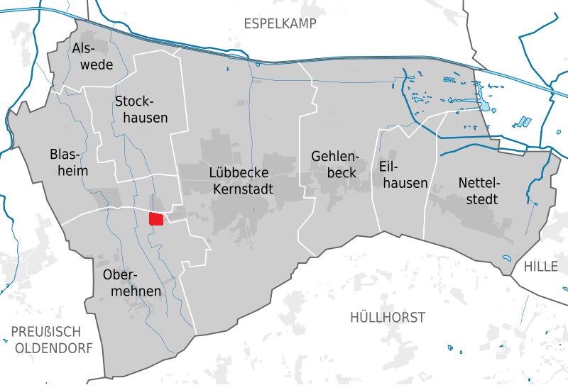
Deutsch: Lage des Blasheimer Marktes |
| Date | |
| Source |
selbst gezeichnet nach Vorlage dieser Karte http://de.wikipedia.org/wiki/Datei:L%C3%BCbbecke_subdivisions.svg Based on •Kataster- und Vermessungsamt Kreis Minden-Lübbecke: Kreiskarte mit Gemeinde- u. Gemarkungsgrenzen (PDF) •Stadt Lübbecke (Hrsg.): Straßenverzeichnis (Straßenverzeichnis der Zuständigkeiten der Ortsvorsteher von Blasheim, Stockhausen und Obermehnen) Bereit gestellt per E-Mail •Gerd-Heinrich Niemeyer (Hrsg.): Stockhauser Blätter. Nr. 22 (= März 2009). (Karte mit den Grenzen des Dorfes 1974) •OpenStreetMap Data (© OpenStreetMap und Mitwirkende, CC-BY-SA) |
| Author | User:TUBS/ Falk Oberdorf |
Licensing edit
- You are free:
- to share – to copy, distribute and transmit the work
- to remix – to adapt the work
- Under the following conditions:
- attribution – You must give appropriate credit, provide a link to the license, and indicate if changes were made. You may do so in any reasonable manner, but not in any way that suggests the licensor endorses you or your use.
- share alike – If you remix, transform, or build upon the material, you must distribute your contributions under the same or compatible license as the original.

|
Permission is granted to copy, distribute and/or modify this document under the terms of the GNU Free Documentation License, Version 1.2 or any later version published by the Free Software Foundation; with no Invariant Sections, no Front-Cover Texts, and no Back-Cover Texts. A copy of the license is included in the section entitled GNU Free Documentation License. |
Original upload log edit
Transferred from de.wikipedia to Commons by Wdwdbot using script bot_filetrans.pl (r80:81M).
- 2011-01-07 14:25:44 Flk-Brdrf (123596 Bytes) {{Information |Beschreibung = Lage des Blasheimer Marktes |Quelle = selbst gezeichnet nach Vorlage dieser Karte http://de.wikipedia.org/wiki/Datei:L%C3%BCbbecke_subdivisions.svg Based on •Kataster- und Vermessungsamt Kreis Minden-Lübbeck
- 2011-01-07 14:25:16 Flk-Brdrf (123596 Bytes) {{Information |Beschreibung = Lage des Blasheimer Marktes |Quelle = selbst gezeichnet nach Vorlage dieser Karte http://de.wikipedia.org/wiki/Datei:L%C3%BCbbecke_subdivisions.svg Based on •Kataster- und Vermessungsamt Kreis Minden-Lübbecke
File history
Click on a date/time to view the file as it appeared at that time.
| Date/Time | Thumbnail | Dimensions | User | Comment | |
|---|---|---|---|---|---|
| current | 20:38, 19 March 2017 | | 800 × 550 (121 KB) | Wdwdbot (talk | contribs) | Bot Move: Original uploader of this revision (#2) was Flk-Brdrf at de.wikipedia |
| 20:38, 19 March 2017 |  | 800 × 550 (121 KB) | Wdwdbot (talk | contribs) | Bot Move: Original uploader of this revision (#1) was Flk-Brdrf at de.wikipedia |
You cannot overwrite this file.
File usage on Commons
There are no pages that use this file.
File usage on other wikis
The following other wikis use this file:
- Usage on de.wikipedia.org