File:Falk Oberdorf Stemweder Berg Bodennutzung.jpg

Size of this preview: 800 × 544 pixels. Other resolutions: 320 × 218 pixels | 640 × 436 pixels | 908 × 618 pixels.
Original file (908 × 618 pixels, file size: 129 KB, MIME type: image/jpeg)
Captions
Captions
Add a one-line explanation of what this file represents
Summary edit
| Description |
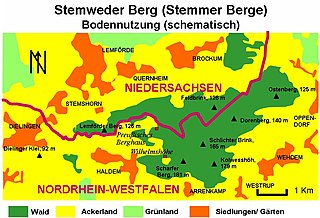
Deutsch: Bodennutzung des Stemweder Berges |
| Date | |
| Source | Own work (Original text: selbst erstellt) |
| Author | Falk Oberdorf, Osterstr. 8, 32312 Lübbecke |
| Permission (Reusing this file) |
(FalkOberdorf 00:04, 23. Feb. 2008 (CET)[User:FalkOberdorf]) |
| Object location | | View this and other nearby images on: OpenStreetMap |
|---|
Licensing edit
| I, the copyright holder of this work, release this work into the public domain. This applies worldwide. In some countries this may not be legally possible; if so: I grant anyone the right to use this work for any purpose, without any conditions, unless such conditions are required by law. |
Original upload log edit
Transferred from de.wikipedia to Commons by TUBS using CommonsHelper.
The original description page was here. All following user names refer to de.wikipedia.
- 2008-02-22 23:04 FalkOberdorf 908×618× (132254 bytes) {{Information |Beschreibung = Bodennutzung des Stemweder Berges |Quelle = selbst erstellt |Urheber = Falk Oberdorf, Osterstr. 8, 32312 Lübbecke |Datum = 19.02.2008 |Genehmigung = ~~~~[User:FalkOberdorf] |Andere Versionen = |Anmerkungen = }}
File history
Click on a date/time to view the file as it appeared at that time.
| Date/Time | Thumbnail | Dimensions | User | Comment | |
|---|---|---|---|---|---|
| current | 16:18, 3 April 2009 | | 908 × 618 (129 KB) | File Upload Bot (Magnus Manske) (talk | contribs) | {{BotMoveToCommons|de.wikipedia|year={{subst:CURRENTYEAR}}|month={{subst:CURRENTMONTHNAME}}|day={{subst:CURRENTDAY}}}} {{Information |Description={{de|Bodennutzung des Stemweder Berges}} |Source=Transferred from [http://de.wikipedia.org de.wikipedia]; tr |
You cannot overwrite this file.
File usage on Commons
There are no pages that use this file.
File usage on other wikis
The following other wikis use this file:
- Usage on de.wikipedia.org