File:Falkland Islands (MODIS 2020-08-17).jpg
Size of this preview: 709 × 600 pixels. Other resolutions: 284 × 240 pixels | 567 × 480 pixels | 908 × 768 pixels | 1,210 × 1,024 pixels | 2,420 × 2,048 pixels | 2,977 × 2,519 pixels.
Original file (2,977 × 2,519 pixels, file size: 463 KB, MIME type: image/jpeg)
Captions
Captions
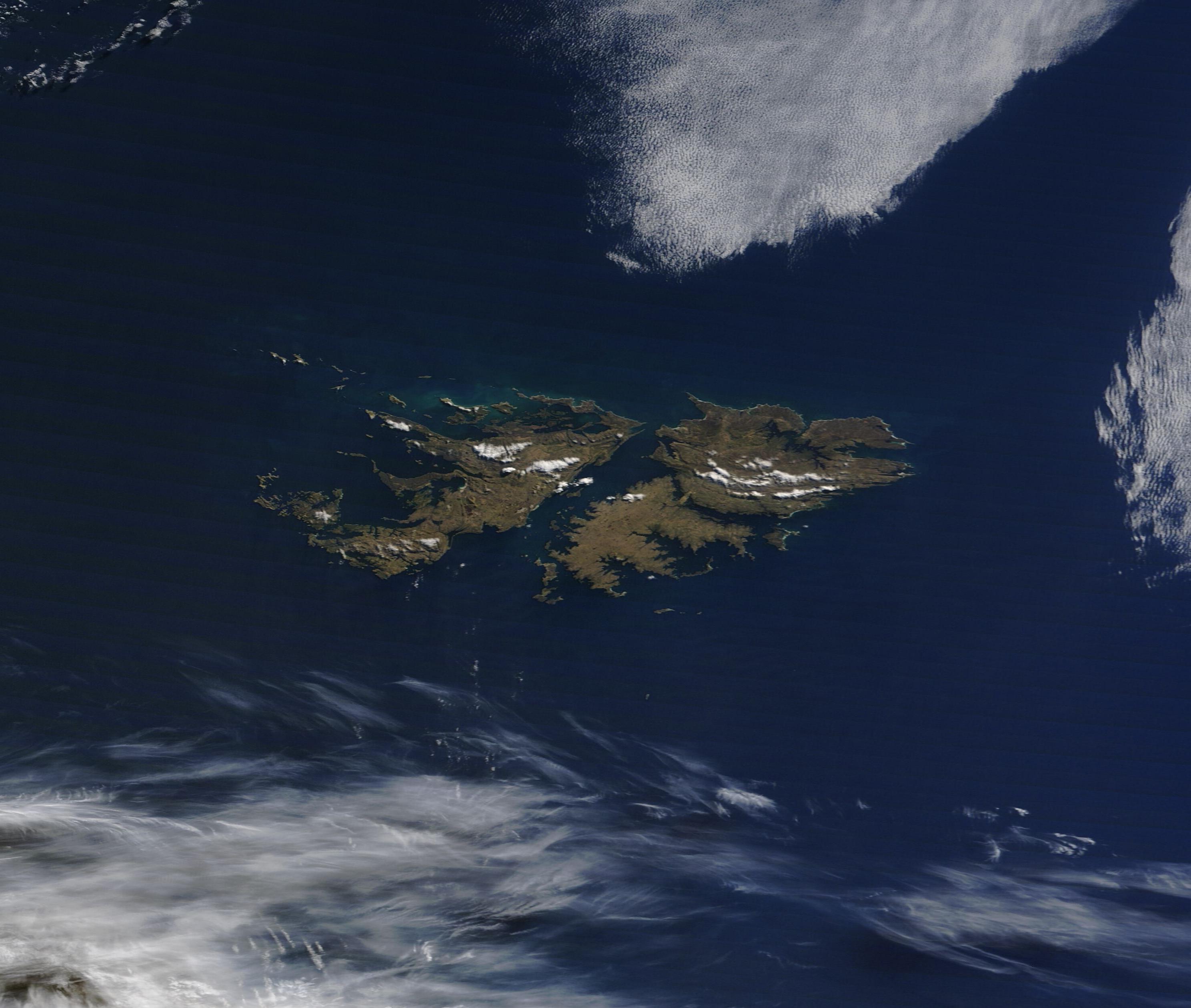
On August 5, 2020, NASA’s Terra satellite passed over the Atlantic Ocean off the coast of southern Argentina, allowing the Moderate Resolution Imaging Spectroradiometer (MODIS) on board to acquire a true-color image of the Falkland Islands.
Summary
edit.jpg&action=edit§ion=1)
| Description |
English: On August 5, 2020, NASA’s Terra satellite passed over the Atlantic Ocean off the coast of southern Argentina, allowing the Moderate Resolution Imaging Spectroradiometer (MODIS) on board to acquire a true-color image of the Falkland Islands.
The islands sit about 400 miles (600 km) east of Argentina and about 850 miles (1,350 km) north of the Antarctic Circle. Just slightly larger than the state of Connecticut, this self-governing territory of the United Kingdom contains about 778 islands. The two largest, East Falkland and West Falkland, are seen in this image. The name of the archipelago comes from the Falkland Sound – the waterway that divides these two large islands. The Falkland Islands have a cool, moist climate that varies minimally throughout the year. Average annual temperatures are about 5.6°C (42°F). Temperatures reach as high as 24°C (76°F) in summer and as low as -5°C (22°F) in winter. Rainfall is comparatively low and evenly distributed throughout the year, averaging 625 millimeters (25 inches) in Stanley, the capital city. Few trees grow on the islands. Instead, grassland and heath—which is widely used as pastureland for sheep and cattle—dominate the landscape. There are more sheep and cattle in the Falkland Islands than people, who only number around 2,000 souls. Pasturage is also used for a herd of reindeer, which were introduced in 2001 from South Georgia in hopes of diversifying the economy through the production of specialty meat. The CIA World Factbook states that this herd has the distinction of being the only commercial reindeer herd in the world unaffected by the 1986 Chernobyl disaster. The reindeer, however, contribute to the overgrazing that threatens important habitats on the islands. |
||
| Date | Taken on 5 August 2020 | ||
| Source |
Falkland Islands (direct link)
|
||
| Author | MODIS Land Rapid Response Team, NASA GSFC |
| This media is a product of the Terra mission Credit and attribution belongs to the mission team, if not already specified in the "author" row |
Licensing
edit.jpg&action=edit§ion=2)
| This file is in the public domain in the United States because it was solely created by NASA. NASA copyright policy states that "NASA material is not protected by copyright unless noted". (See Template:PD-USGov, NASA copyright policy page or JPL Image Use Policy.) | ||
 |
Warnings:
|
File history
Click on a date/time to view the file as it appeared at that time.
| Date/Time | Thumbnail | Dimensions | User | Comment | |
|---|---|---|---|---|---|
| current | 02:51, 17 February 2024 | | 2,977 × 2,519 (463 KB) | OptimusPrimeBot (talk | contribs) | #Spacemedia - Upload of http://modis.gsfc.nasa.gov/gallery/images/image08172020_250m.jpg via Commons:Spacemedia |
You cannot overwrite this file.
File usage on Commons
The following page uses this file:
.jpg&oldid=852727548)