File:FalklandsPatagoniaGeography.svg

Size of this PNG preview of this SVG file: 800 × 439 pixels. Other resolutions: 320 × 175 pixels | 640 × 351 pixels | 1,024 × 561 pixels | 1,280 × 702 pixels | 2,560 × 1,404 pixels | 1,262 × 692 pixels.
Original file (SVG file, nominally 1,262 × 692 pixels, file size: 1.25 MB)
Captions
Captions
Add a one-line explanation of what this file represents
Summary edit
| Description |
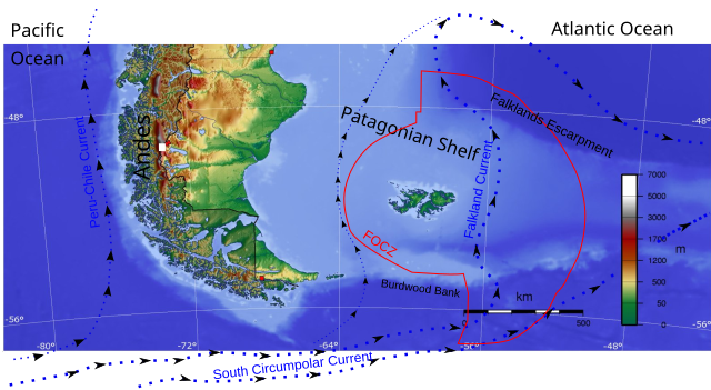
English: Principal geographical features of they Falkland Islands and Patagonia. For purposes of clarity, names of the political units have been omitted. |
| Date | |
| Source | File:Argentina topo blank.jpg |
| Author | Captain Blood |
| Camera location | | View this and other nearby images on: OpenStreetMap |
|---|
Original file cropped and adapted by Martinvl
Licensing edit
This file is licensed under the Creative Commons Attribution-Share Alike 3.0 Unported license.
- You are free:
- to share – to copy, distribute and transmit the work
- to remix – to adapt the work
- Under the following conditions:
- attribution – You must give appropriate credit, provide a link to the license, and indicate if changes were made. You may do so in any reasonable manner, but not in any way that suggests the licensor endorses you or your use.
- share alike – If you remix, transform, or build upon the material, you must distribute your contributions under the same or compatible license as the original.
File history
Click on a date/time to view the file as it appeared at that time.
| Date/Time | Thumbnail | Dimensions | User | Comment | |
|---|---|---|---|---|---|
| current | 20:34, 4 October 2014 | | 1,262 × 692 (1.25 MB) | Martinvl (talk | contribs) | User created page with UploadWizard |
You cannot overwrite this file.
File usage on Commons
The following page uses this file:
File usage on other wikis
The following other wikis use this file:
- Usage on es.wikibooks.org