File:Falmagne Landscape R02.jpg
![File:Falmagne Landscape R02.jpg](https://upload.wikimedia.org/wikipedia/commons/thumb/5/5a/Falmagne_Landscape_R02.jpg/800px-Falmagne_Landscape_R02.jpg?20141023095013)
Size of this preview: 800 × 530 pixels. Other resolutions: 320 × 212 pixels | 640 × 424 pixels | 1,024 × 678 pixels | 1,280 × 848 pixels | 2,560 × 1,696 pixels | 4,552 × 3,016 pixels.
Original file (4,552 × 3,016 pixels, file size: 10.78 MB, MIME type: image/jpeg)
File information
Structured data
Captions
Captions
Add a one-line explanation of what this file represents
Summary
editDescriptionFalmagne Landscape R02.jpg |
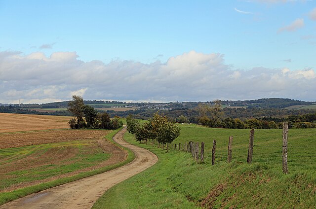
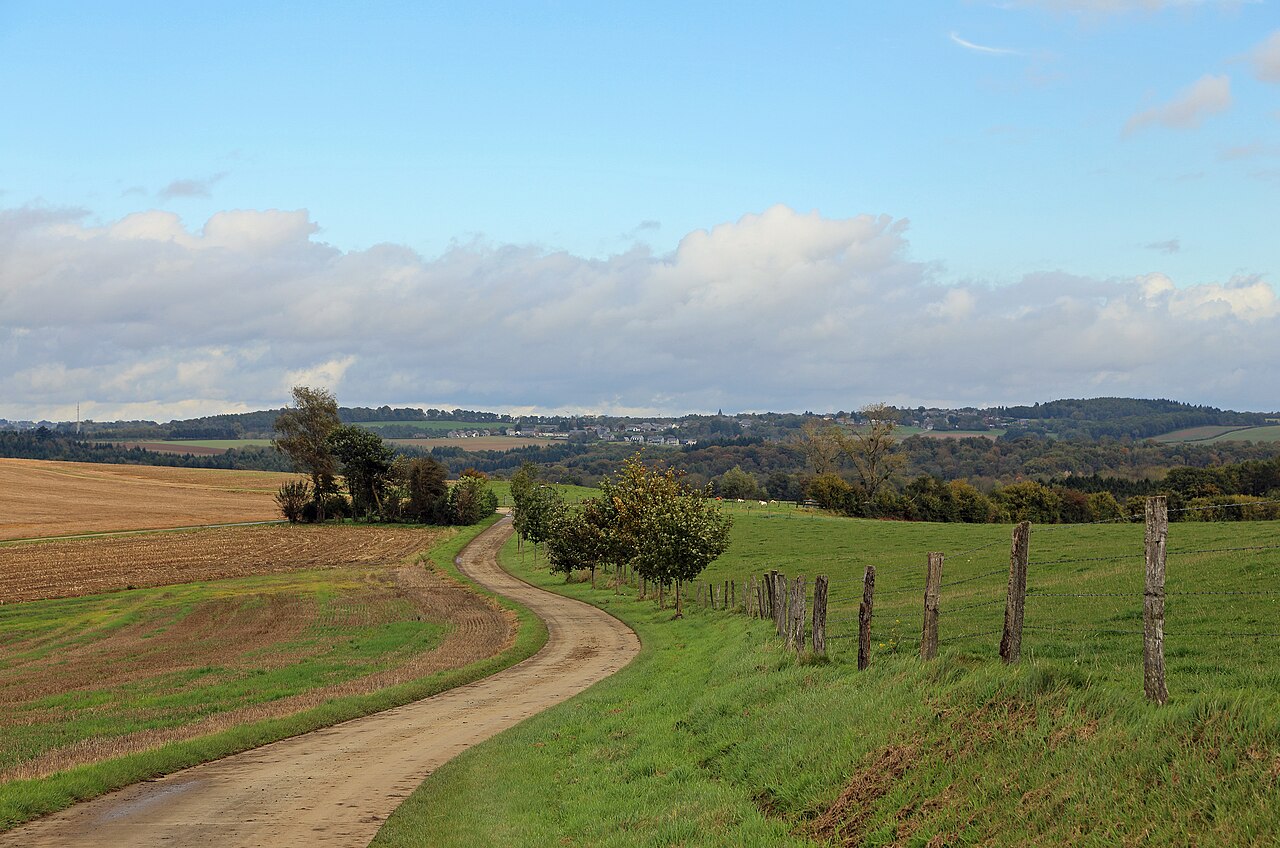
Nederlands: Falmagne (gem. Dinant, provincie Namen, België): landschap. In de verte: de vallei van de Lesse en het dorp Dréhance. English: Falmagne (municipality of Dinant, province of Namur, Belgium): landscape. In the distance: the valley of the Lesse river and the village of Dréhance. Français : Falmagne (commune de Dinant, province de Namur, Belgique) : paysage. Au loin : la vallée de la Lesse et le village de Dréhance. |
Date | |
Source | Own work |
Author | Marc Ryckaert (MJJR) |
Camera location | 50° 12′ 18.59″ N, 4° 54′ 27.53″ E ![]() | View this and other nearby images on: OpenStreetMap | ![]() |
---|
Licensing
editI, the copyright holder of this work, hereby publish it under the following license:
![w:en:Creative Commons](https://upload.wikimedia.org/wikipedia/commons/thumb/7/79/CC_some_rights_reserved.svg/90px-CC_some_rights_reserved.svg.png)
![attribution](https://upload.wikimedia.org/wikipedia/commons/thumb/1/11/Cc-by_new_white.svg/24px-Cc-by_new_white.svg.png)
This file is licensed under the Creative Commons Attribution 3.0 Unported license.
- You are free:
- to share – to copy, distribute and transmit the work
- to remix – to adapt the work
- Under the following conditions:
- attribution – You must give appropriate credit, provide a link to the license, and indicate if changes were made. You may do so in any reasonable manner, but not in any way that suggests the licensor endorses you or your use.
File history
Click on a date/time to view the file as it appeared at that time.
Date/Time | Thumbnail | Dimensions | User | Comment | |
---|---|---|---|---|---|
current | 09:50, 23 October 2014 | ![]() | 4,552 × 3,016 (10.78 MB) | MJJR (talk | contribs) | User created page with UploadWizard |
You cannot overwrite this file.
File usage on Commons
There are no pages that use this file.
Metadata
This file contains additional information such as Exif metadata which may have been added by the digital camera, scanner, or software program used to create or digitize it. If the file has been modified from its original state, some details such as the timestamp may not fully reflect those of the original file. The timestamp is only as accurate as the clock in the camera, and it may be completely wrong.
Camera manufacturer | Canon |
---|---|
Camera model | Canon EOS 6D |
Exposure time | 1/250 sec (0.004) |
F-number | f/7.1 |
ISO speed rating | 100 |
Date and time of data generation | 13:04, 16 October 2014 |
Lens focal length | 70 mm |
Latitude | 50° 12′ 18.59″ N |
Longitude | 4° 54′ 27.53″ E |
Altitude | 223.8 meters above sea level |
Orientation | Normal |
Horizontal resolution | 350 dpi |
Vertical resolution | 350 dpi |
Software used | Adobe Photoshop Elements 6.0 Macintosh |
File change date and time | 18:54, 22 October 2014 |
Y and C positioning | Centered |
Exif version | 2.3 |
Date and time of digitizing | 13:04, 16 October 2014 |
Meaning of each component |
|
APEX shutter speed | 8 |
APEX aperture | 5.625 |
APEX exposure bias | 0 |
Flash | Flash did not fire, compulsory flash suppression |
Supported Flashpix version | 1 |
Color space | sRGB |
Focal plane X resolution | 3,810.5849582173 |
Focal plane Y resolution | 3,815.89958159 |
Focal plane resolution unit | inches |
Custom image processing | Normal process |
Exposure mode | Auto exposure |
White balance | Auto white balance |
Scene capture type | Standard |
GPS time (atomic clock) | 11:01 |
Satellites used for measurement | 12 |
Receiver status | Measurement in progress |
Geodetic survey data used | WGS-84 |
GPS date | 16 October 2014 |
GPS tag version | 0.0.3.2 |
Supported Flashpix version | 1 |
Image width | 4,552 px |
Image height | 3,016 px |
Rating (out of 5) | 0 |
Date metadata was last modified | 20:54, 22 October 2014 |