File:Fang Mountain winter rime.jpg
![File:Fang Mountain winter rime.jpg](https://upload.wikimedia.org/wikipedia/commons/thumb/e/e8/Fang_Mountain_winter_rime.jpg/800px-Fang_Mountain_winter_rime.jpg?20200419101108)
Size of this preview: 800 × 531 pixels. Other resolutions: 320 × 212 pixels | 640 × 425 pixels | 1,024 × 680 pixels | 1,280 × 850 pixels | 2,784 × 1,848 pixels.
Original file (2,784 × 1,848 pixels, file size: 3.61 MB, MIME type: image/jpeg)
File information
Structured data
Captions
Captions
Add a one-line explanation of what this file represents
Summary
editDescriptionFang Mountain winter rime.jpg |
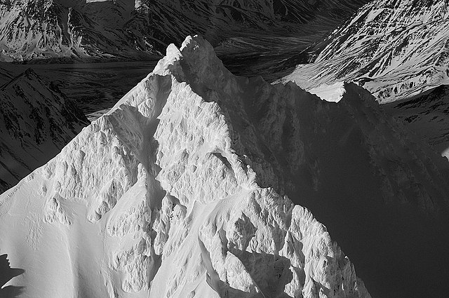
English: Aerial of Fang Mountain in winter covered with rime |
Date | |
Source | https://www.flickr.com/photos/alaskanps/33365566915/ |
Author | National Park Service, Alaska Region |
Camera location | 63° 28′ 46.65″ N, 149° 10′ 10.87″ W ![]() | View this and other nearby images on: OpenStreetMap | ![]() |
---|
Licensing
edit![]() |
This image was originally posted to Flickr by AlaskaNPS at https://flickr.com/photos/75182224@N04/33365566915. It was reviewed on 19 April 2020 by FlickreviewR 2 and was confirmed to be licensed under the terms of the Public Domain Mark. |
19 April 2020
Public domainPublic domainfalsefalse |
![]() |
This image or media file contains material based on a work of a National Park Service employee, created as part of that person's official duties. As a work of the U.S. federal government, such work is in the public domain in the United States. See the NPS website and NPS copyright policy for more information. | ![]() |
File history
Click on a date/time to view the file as it appeared at that time.
Date/Time | Thumbnail | Dimensions | User | Comment | |
---|---|---|---|---|---|
current | 10:11, 19 April 2020 | ![]() | 2,784 × 1,848 (3.61 MB) | Ron Clausen (talk | contribs) | Uploaded a work by National Park Service, Alaska Region from https://www.flickr.com/photos/alaskanps/33365566915/ with UploadWizard |
You cannot overwrite this file.
File usage on Commons
The following page uses this file:
File usage on other wikis
The following other wikis use this file:
- Usage on en.wikipedia.org
Metadata
This file contains additional information such as Exif metadata which may have been added by the digital camera, scanner, or software program used to create or digitize it. If the file has been modified from its original state, some details such as the timestamp may not fully reflect those of the original file. The timestamp is only as accurate as the clock in the camera, and it may be completely wrong.
Camera manufacturer | NIKON CORPORATION |
---|---|
Camera model | NIKON D700 |
Author | Picasa |
Exposure time | 1/400 sec (0.0025) |
F-number | f/18 |
ISO speed rating | 250 |
Date and time of data generation | 14:37, 31 January 2014 |
Lens focal length | 55 mm |
Latitude | 63° 28′ 46.65″ N |
Longitude | 149° 10′ 10.87″ W |
Altitude | 2,149.098 meters above sea level |
Image title |
|
Horizontal resolution | 300 dpi |
Vertical resolution | 300 dpi |
Software used | RoboGEO v5.6.18 |
File change date and time | 12:41, 18 August 2016 |
Y and C positioning | Co-sited |
Exposure Program | Shutter priority |
Exif version | 2.21 |
Date and time of digitizing | 14:37, 31 January 2014 |
Meaning of each component |
|
Image compression mode | 4 |
APEX exposure bias | 0 |
Maximum land aperture | 5 APEX (f/5.66) |
Metering mode | Center weighted average |
Light source | Unknown |
Flash | Flash did not fire |
DateTime subseconds | 33 |
DateTimeOriginal subseconds | 33 |
DateTimeDigitized subseconds | 33 |
Supported Flashpix version | 1 |
Color space | sRGB |
Sensing method | One-chip color area sensor |
File source | Digital still camera |
Scene type | A directly photographed image |
Custom image processing | Normal process |
Exposure mode | Auto exposure |
White balance | Auto white balance |
Digital zoom ratio | 1.53 |
Focal length in 35 mm film | 82 mm |
Scene capture type | Standard |
Scene control | None |
Contrast | Normal |
Saturation | Normal |
Sharpness | Normal |
Subject distance range | Unknown |
Unique image ID | f894e6b1606ef0b8f73815ac0bb7fb98 |
GPS time (atomic clock) | 23:37 |
Geodetic survey data used | WGS 1984 |
GPS date | 31 January 2014 |
GPS tag version | 2.2.0.0 |
IIM version | 4 |