File:Far east.png

Size of this preview: 800 × 352 pixels. Other resolutions: 320 × 141 pixels | 640 × 282 pixels | 1,427 × 628 pixels.
Original file (1,427 × 628 pixels, file size: 48 KB, MIME type: image/png)
Captions
Captions
Add a one-line explanation of what this file represents
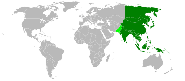
English: Map of the Far East — as a cultural block and in historical perception, it includes: 1. South Asia (greater Indian Subcontinent); 2. Himalayas; 3. East Asia; 4. Northeast Asia; and 5. Southeast Asia (geographic Indochina and Malesia).
- Pakistan is part of South Asia, though socio-politically is occasionally classified as a Middle Eastern country. The cultural border of the Far East is therefore thought of as Pakistan and India, north through western China and eastern Siberia.
| |
This work has been released into the public domain by its author, Vastu, at the English Wikipedia project. This applies worldwide. In case this is not legally possible: |
File history
Click on a date/time to view the file as it appeared at that time.
| Date/Time | Thumbnail | Dimensions | User | Comment | |
|---|---|---|---|---|---|
| current | 20:40, 5 July 2006 | | 1,427 × 628 (48 KB) | Chico (talk | contribs) | The '''far east''' as a cultural block includes East Asia, Southeast Asia, Northeast Asia and South Asia. Pakistan is occasionally thought of as a middle eastern country, but is part of South Asia. The cultural border of the far east is therefore thought |
You cannot overwrite this file.
File usage on Commons
The following 2 pages use this file:
File usage on other wikis
The following other wikis use this file:
- Usage on be.wikipedia.org
- Usage on ca.wikipedia.org
- Usage on cv.wikipedia.org
- Usage on de.wikipedia.org
- Usage on eu.wikipedia.org
- Usage on frp.wikipedia.org
- Usage on hu.wikipedia.org
- Usage on it.wikipedia.org
- Usage on pl.wiktionary.org
- Usage on pt.wikiquote.org
- Usage on uk.wikipedia.org
- Usage on zh-min-nan.wikipedia.org
- Usage on zh-yue.wikipedia.org