File:Fer - Cap de Bonne Esperance.png

Size of this preview: 800 × 567 pixels. Other resolutions: 320 × 227 pixels | 640 × 453 pixels | 1,024 × 725 pixels | 1,280 × 906 pixels | 1,977 × 1,400 pixels.
Original file (1,977 × 1,400 pixels, file size: 5.03 MB, MIME type: image/png)
Captions
Captions
Add a one-line explanation of what this file represents
Summary
edit
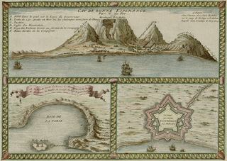
Nicolas de Fer: Cap de Bonne Espérance, 1705
L'Atlas Curieux Ou Le Monde Répresenté Dans Des Cartes Générales Et Particulières Du Ciel Et De La Terre
| Nicolas de Fer
(–1720) |
|||
|---|---|---|---|
 |
|||
| Description | French engraver and cartographer | ||
| Date of birth/death |
1646 / 1647 |
25 October 1720 | |
| Location of birth/death | Paris | Paris | |
| Work location | |||
| Authority file | |||
Licensing
edit
|
This is a faithful photographic reproduction of a two-dimensional, public domain work of art. The work of art itself is in the public domain for the following reason:
The official position taken by the Wikimedia Foundation is that "faithful reproductions of two-dimensional public domain works of art are public domain".
This photographic reproduction is therefore also considered to be in the public domain in the United States. In other jurisdictions, re-use of this content may be restricted; see Reuse of PD-Art photographs for details. | ||||
File history
Click on a date/time to view the file as it appeared at that time.
| Date/Time | Thumbnail | Dimensions | User | Comment | |
|---|---|---|---|---|---|
| current | 00:22, 27 September 2005 | | 1,977 × 1,400 (5.03 MB) | Frank Schulenburg (talk | contribs) | Nicolas de Fer: ''Cap de Bonne Espérance'', 1705 L'Atlas Curieux Ou Le Monde Répresenté Dans Des Cartes Générales Et Particulières Du Ciel Et De La Terre {{Creator:Nicolas de Fer}} Category:18th century maps |
You cannot overwrite this file.
File usage on Commons
The following page uses this file:
File usage on other wikis
The following other wikis use this file:
- Usage on fr.wikipedia.org
- Usage on it.wikipedia.org
- Usage on nl.wikipedia.org