File:Fergana Valley map-de.svg

Size of this PNG preview of this SVG file: 800 × 599 pixels. Other resolutions: 320 × 240 pixels | 640 × 479 pixels | 1,024 × 767 pixels | 1,280 × 958 pixels | 2,560 × 1,917 pixels | 840 × 629 pixels.
Original file (SVG file, nominally 840 × 629 pixels, file size: 1.22 MB)
Captions
Captions
Add a one-line explanation of what this file represents
Summary
edit| Description |
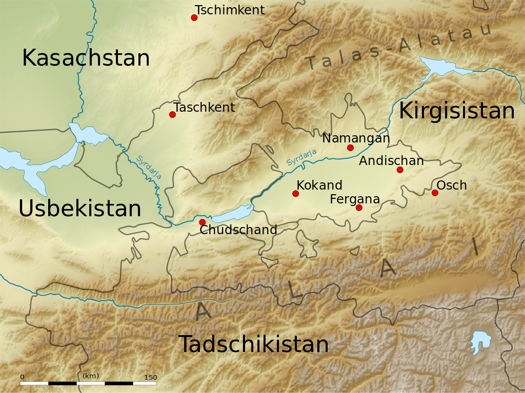
English: Map of the Fergana Valley.
Equirectangular projection. Strechted by 131.0%. Geographic limits of the map:
|
| Date | |
| Source | Own work |
| Author | Uwe Dedering |
| Other versions |
|

Licensing
edit
I, the copyright holder of this work, hereby publish it under the following licenses:
This file is licensed under the Creative Commons Attribution-Share Alike 3.0 Unported license.
- You are free:
- to share – to copy, distribute and transmit the work
- to remix – to adapt the work
- Under the following conditions:
- attribution – You must give appropriate credit, provide a link to the license, and indicate if changes were made. You may do so in any reasonable manner, but not in any way that suggests the licensor endorses you or your use.
- share alike – If you remix, transform, or build upon the material, you must distribute your contributions under the same or compatible license as the original.

|
Permission is granted to copy, distribute and/or modify this document under the terms of the GNU Free Documentation License, Version 1.2 or any later version published by the Free Software Foundation; with no Invariant Sections, no Front-Cover Texts, and no Back-Cover Texts. A copy of the license is included in the section entitled GNU Free Documentation License. |
You may select the license of your choice.
File history
Click on a date/time to view the file as it appeared at that time.
| Date/Time | Thumbnail | Dimensions | User | Comment | |
|---|---|---|---|---|---|
| current | 13:48, 19 June 2010 | | 840 × 629 (1.22 MB) | Uwe Dedering (talk | contribs) | +Chudschand |
| 18:44, 18 June 2010 |  | 840 × 629 (1.22 MB) | Uwe Dedering (talk | contribs) | no text on path | |
| 18:36, 18 June 2010 |  | 840 × 629 (1.22 MB) | Uwe Dedering (talk | contribs) | more minor changes | |
| 17:17, 18 June 2010 |  | 840 × 629 (1.22 MB) | Uwe Dedering (talk | contribs) | some minor edits | |
| 15:46, 18 June 2010 |  | 840 × 629 (1.23 MB) | Uwe Dedering (talk | contribs) | some improvments | |
| 12:53, 17 June 2010 |  | 840 × 629 (1.23 MB) | Uwe Dedering (talk | contribs) | image embedded | |
| 12:47, 17 June 2010 |  | 840 × 629 (185 KB) | Uwe Dedering (talk | contribs) | {{Information |Description={{en|1=Map of the Fergana Valley. Equirectangular projection. Strechted by 131.0%. Geographic limits of the map: * N: 42.5° N * S: 38.5° N * W: 67.0° E * E: 74.0° E Made with Natural Earth. Free vector and raster map data |
You cannot overwrite this file.
File usage on Commons
The following page uses this file:
File usage on other wikis
The following other wikis use this file:
- Usage on ca.wikipedia.org
- Usage on de.wikipedia.org
- Usage on et.wikipedia.org
- Usage on fr.wikipedia.org
- Usage on hsb.wikipedia.org
- Usage on ky.wikipedia.org
- Usage on lt.wikipedia.org
- Usage on ru.wikivoyage.org