File:FerrarisMaastricht.jpg

Original file (671 × 1,730 pixels, file size: 590 KB, MIME type: image/jpeg)
Captions
Captions
Summary edit
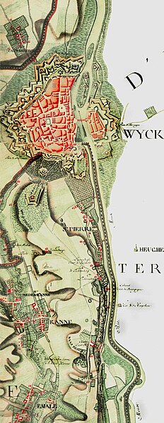
| Description | Uittreksel uit de de Ferrariskaart met Maastricht, tonende de mate van detail en de aard der opgenomen gegevens. |
| Date | 29 April 2005 (original upload date) |
| Source | Kabinetskaarten van de Oostenrijkse Nederlanden opgenomen op initiatief van Graaf de Ferraris (1965-76, Koninklijke Bibliotheek van België).. Originally from nl.wikipedia; description page is/was here. |
| Author | The original uploader was Ed Stevenhagen at Dutch Wikipedia. |
Licensing edit
|
This work is in the public domain in its country of origin and other countries and areas where the copyright term is the author's life plus 70 years or fewer.
| |
| This file has been identified as being free of known restrictions under copyright law, including all related and neighboring rights. | |

|
Attribution information, such as the author's name, e-mail, website, or signature, that was once visible in the image itself has been moved into the image metadata and/or image description page. This makes the image easier to reuse and more language-neutral, and makes the text easier to process and search for. Commons discourages placing visible author information in images.
|
Original upload log edit
(All user names refer to nl.wikipedia)
- 2005-04-29 22:15 Ed Stevenhagen 671×1730×8 (189881 bytes) Uittreksel uit de de Ferrariskaart met Maastricht, tonende de mate van detail en de aard der opgenomen gegevens. Bron: Kabinetskaarten van de Oostenrijkse Nederlanden opgenomen op initiatief van Graaf de Ferraris (1965-76, Koninklijke Bibliotheek van Bel
File history
Click on a date/time to view the file as it appeared at that time.
| Date/Time | Thumbnail | Dimensions | User | Comment | |
|---|---|---|---|---|---|
| current | 01:26, 10 March 2012 | 671 × 1,730 (590 KB) | Jbarta (talk | contribs) | remove watermark (at least I hope that's the/a watermark) | |
| 10:45, 9 April 2007 | 671 × 1,730 (185 KB) | Aleichem (talk | contribs) | from nl: |
You cannot overwrite this file.
File usage on Commons
The following page uses this file:
File usage on other wikis
The following other wikis use this file:
- Usage on de.wikipedia.org
- Usage on en.wikipedia.org
- Usage on fr.wikipedia.org
- Usage on it.wikipedia.org
- Usage on lb.wikipedia.org
- Usage on nl.wikipedia.org