File:Fertile crescent Neolithic B circa 7500 BC.jpg

Size of this preview: 579 × 599 pixels. Other resolutions: 232 × 240 pixels | 464 × 480 pixels | 742 × 768 pixels | 1,050 × 1,087 pixels.
Original file (1,050 × 1,087 pixels, file size: 426 KB, MIME type: image/jpeg)
Captions
Captions
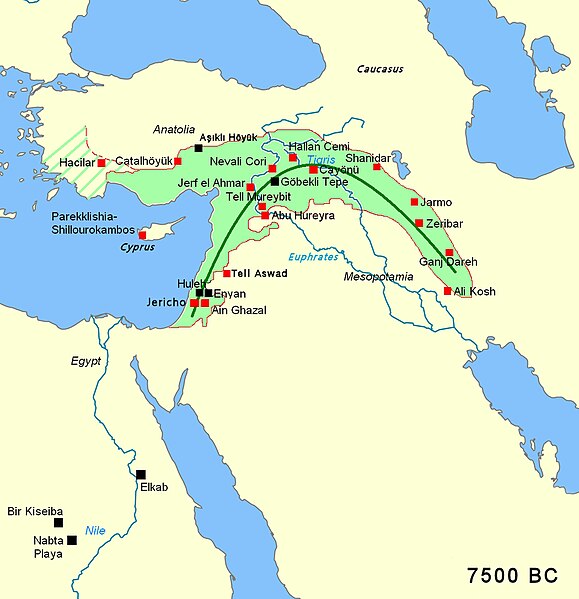
Map of Southwest Asia showing the main archaeological sites of the Pre-Pottery Neolithic period, BCE c. 7500, in the "Fertile Crescent".
Summary edit
| Description |
English: Fertile crescent Neolithic B circa 7500 BC; black squares indicate pre-agricultural sites |
||
| Date | |||
| Source | |||
| Author | Bjoertvedt | ||
| Other versions |
|


Licensing edit
This file is licensed under the Creative Commons Attribution-Share Alike 3.0 Unported license.
Attribution: GFDL
- You are free:
- to share – to copy, distribute and transmit the work
- to remix – to adapt the work
- Under the following conditions:
- attribution – You must give appropriate credit, provide a link to the license, and indicate if changes were made. You may do so in any reasonable manner, but not in any way that suggests the licensor endorses you or your use.
- share alike – If you remix, transform, or build upon the material, you must distribute your contributions under the same or compatible license as the original.
| Annotations | This image is annotated: View the annotations at Commons |
File history
Click on a date/time to view the file as it appeared at that time.
| Date/Time | Thumbnail | Dimensions | User | Comment | |
|---|---|---|---|---|---|
| current | 16:14, 12 April 2024 | | 1,050 × 1,087 (426 KB) | Iktsokh (talk | contribs) | Clearing the map |
| 20:04, 22 April 2019 |  | 1,050 × 1,087 (479 KB) | पाटलिपुत्र (talk | contribs) | better | |
| 20:02, 22 April 2019 |  | 1,050 × 1,087 (480 KB) | पाटलिपुत्र (talk | contribs) | better | |
| 15:47, 22 April 2019 |  | 1,050 × 1,087 (466 KB) | पाटलिपुत्र (talk | contribs) | Improved accuracy | |
| 14:51, 22 April 2019 |  | 1,050 × 1,087 (466 KB) | पाटलिपुत्र (talk | contribs) | User created page with UploadWizard |
You cannot overwrite this file.
File usage on Commons
The following page uses this file:
File usage on other wikis
The following other wikis use this file:
- Usage on af.wikipedia.org
- Usage on ar.wikipedia.org
- Usage on az.wikipedia.org
- Usage on bg.wikipedia.org
- Usage on bn.wikipedia.org
- Usage on bs.wikipedia.org
- Usage on ca.wikipedia.org
- Usage on cy.wikipedia.org
- Usage on de.wikipedia.org
- Usage on el.wikipedia.org
- Usage on en.wikipedia.org
- Jericho
- Fertile Crescent
- 8th millennium BC
- Tell Abu Hureyra
- History of the Middle East
- Neolithic Revolution
- Jarmo
- Pre-Pottery Neolithic B
- Mureybet
- ʿAin Ghazal
- History of Mesopotamia
- Ganj Dareh
- Aşıklı Höyük
- Pre-Pottery Neolithic
- Neolithic Greece
- Ali Kosh
- Tell Aswad
- Tell Sabi Abyad
- Art of Mesopotamia
- Jerf el Ahmar
- User:Abyssal/Prehistory of Asia
- Trialetian Mesolithic
- Usage on en.wikivoyage.org
- Usage on es.wikipedia.org
View more global usage of this file.