File:Fertility rate world map 2.png

Size of this preview: 800 × 410 pixels. Other resolutions: 320 × 164 pixels | 864 × 443 pixels.
Original file (864 × 443 pixels, file size: 113 KB, MIME type: image/png)
Captions
Captions
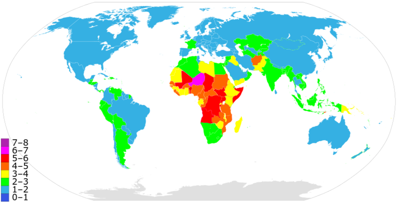
Global fertility rates as of 2020

|
File:Total Fertility Rate Map by Country.svg is a vector version of this file. It should be used in place of this PNG file when not inferior.
File:Fertility rate world map 2.png → File:Total Fertility Rate Map by Country.svg
For more information, see Help:SVG. |
 |
Summary
edit
A more precise world map of country fertility rates, as listed at w:List of countries and territories by fertility rate. Note that this version is using outdated data; newer figures (e.g. 2015) are available
See also: Image:Fertility rate world map.PNG from 2006.
Licensing
edit
| I, the copyright holder of this work, release this work into the public domain. This applies worldwide. In some countries this may not be legally possible; if so: I grant anyone the right to use this work for any purpose, without any conditions, unless such conditions are required by law. |
File history
Click on a date/time to view the file as it appeared at that time.
| Date/Time | Thumbnail | Dimensions | User | Comment | |
|---|---|---|---|---|---|
| current | 21:49, 23 April 2022 | | 864 × 443 (113 KB) | Innab (talk | contribs) | Updated with new 2020 data from CIA Factbook: https://www.cia.gov/the-world-factbook/field/total-fertility-rate/country-comparison#:~:text=Total%20fertility%20rate%20(TFR)%20compares,fertility%20rate%20at%20each%20age. |
| 06:05, 12 February 2020 |  | 864 × 443 (113 KB) | Innab (talk | contribs) | Updated with new 2020 data from CIA Factbook: https://www.cia.gov/library/publications/the-world-factbook/fields/356rank.html | |
| 19:59, 2 December 2018 |  | 856 × 435 (117 KB) | Innab (talk | contribs) | Updated old 2006 version with new 2018 version | |
| 03:31, 17 June 2006 |  | 1,357 × 628 (40 KB) | PlatypeanArchcow (talk | contribs) | A more precise world map of country fertility rates, as listed at w:List of countries and territories by fertility rate. |
You cannot overwrite this file.
File usage on Commons
The following 2 pages use this file:
File usage on other wikis
The following other wikis use this file:
- Usage on ar.wikipedia.org
- Usage on ast.wikipedia.org
- Usage on azb.wikipedia.org
- Usage on ba.wikipedia.org
- Usage on bg.wikipedia.org
- Usage on bn.wikipedia.org
- Usage on ca.wikipedia.org
- Usage on cs.wikipedia.org
- Usage on de.wikipedia.org
- Usage on en.wikipedia.org
- Usage on eo.wikipedia.org
- Usage on es.wikipedia.org
- Usage on et.wikipedia.org
- Usage on eu.wikipedia.org
- Usage on fa.wikipedia.org
- Usage on fi.wikipedia.org
- Usage on fr.wikipedia.org
- Usage on he.wikipedia.org
- Usage on hy.wikipedia.org
- Usage on id.wikipedia.org
- Usage on it.wikipedia.org
- Usage on kk.wikipedia.org
- Usage on ko.wikipedia.org
- Usage on nl.wikipedia.org
- Usage on or.wikipedia.org
- Usage on pt.wikipedia.org
- Usage on ru.wikipedia.org
- Население Земли
- Африка
- Демографический кризис в Российской Федерации
- Рождаемость
- Демографический переход
- Суммарный коэффициент рождаемости
- Демографические проблемы
- Демографическое старение
- Депопуляция
- Чёрная Африка
- Перенаселение
- Мальтузианская ловушка
- Контроль рождаемости
- Список стран по суммарному коэффициенту рождаемости
- Википедия:Синдром детства
- Демографический дивиденд
- Участник:Resen1x/Черновик2
View more global usage of this file.