File:Fes el-Jdid plan (version 2).png
Original file (967 × 830 pixels, file size: 162 KB, MIME type: image/png)
Captions
Captions
Summary
edit.png&action=edit§ion=1)
| Description |
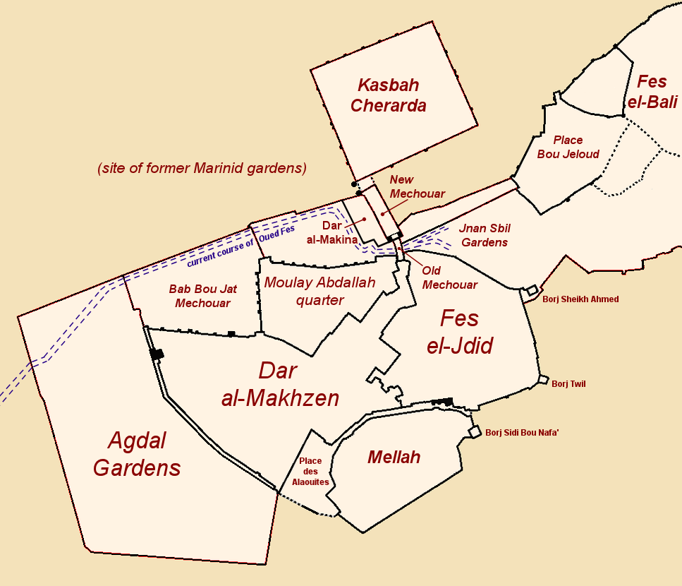
English: Plan of Fes el-Jdid, showing its major divisions, including the Dar al-Makhzen.
Note: This is a revised/modified version of "Fes el-Jdid plan.png". I've uploaded it separately and labelled it "version 2" as it's possible some may find it aesthetically worse than the other version. The main differences are: 1) The approximate course of the river has been added on the map, as this something mentioned a few times in the article for which this was intended. (I drew this based on maps in reliable sources and also by checking it visually on Google satellite imagery.) 2) Some details have been added to reflect some of the fortified gate structures of Bab Dekkakin, Bab al-Amer, Bab Semmarine, and Bab Agdal. 3) Minor but significant changes to the outline of the walls on the right side of the Old Mechouar, in order to visually reflect the roads in and out of it as well as to make it easier to draw the course of the river emerging on this side. Note, however, that the more irregular outline of the walls in the previous version (which was the outline drawn by user Omar-Toons) is partly more accurate because there is in fact a wall that runs in that manner there. For the purposes of visually explaining Fes el-Jdid's layout, I felt that this was an ok compromise.Français : Plan de Fes el Jdid, avec ses parties principales, incluant le Dar al-Makhzen.
Note: Ici une version révisée/modifiée de "Fes el-Jdid plan.png". Je l'ai téléchargé séparément et nommé "version 2" puisqu'il est possible que certains la trouveront moins agréable esthétiquement que la version précédente. Les différence principales sont: 1) Le cours approximatif de la rivière a été ajouté, car c'est un sujet mentionné quelques fois sur la page pour laquelle la carte était conçue. (Je l'ai dessiné en consultant des cartes dans des sources fiables et en vérifiant visuellement les images satellites de Google.) 2) Certains détails ont été ajoutés pour indiquer les structures fortifiées des portes Bab Dekkakine, Bab al-Amer, Bab Semmarine, et Bab Agdal. 3) Des modifications mineures mais significatifs au tracée des remparts à droite du Vieux Méchouar; afin de représenter plutôt les chemins et les rues qui y mènent et pour dessiner plus facilement le cours de la rivière qui ressort de ce côté. À noter, par contre, que le tracée plutôt irrégulier des remparts dans la version précédente (le tracée dessiné par Omar-toons) est en fait plus exact car il existe véritablement un rempart avec ce trajet dans cet endroit. Dans le bût d'expliquer visuellement le plan de Fes el Jdid, toutefois, j'ai constaté que c'était un compromis acceptable. |
| Date | |
| Source | Own work |
| Author | Robert Prazeres |
Licensing
edit.png&action=edit§ion=2)
- You are free:
- to share – to copy, distribute and transmit the work
- to remix – to adapt the work
- Under the following conditions:
- attribution – You must give appropriate credit, provide a link to the license, and indicate if changes were made. You may do so in any reasonable manner, but not in any way that suggests the licensor endorses you or your use.
- share alike – If you remix, transform, or build upon the material, you must distribute your contributions under the same or compatible license as the original.
File history
Click on a date/time to view the file as it appeared at that time.
| Date/Time | Thumbnail | Dimensions | User | Comment | |
|---|---|---|---|---|---|
| current | 07:21, 5 April 2020 | | 967 × 830 (162 KB) | R Prazeres (talk | contribs) | Uploaded own work with UploadWizard |
You cannot overwrite this file.
File usage on Commons
The following 2 pages use this file:
-he.png)
File usage on other wikis
The following other wikis use this file:
- Usage on en.wikipedia.org
- Usage on es.wikipedia.org
- Usage on he.wikipedia.org
.png&oldid=508475570)