File:Firebreak on SE flank of Meall Odhar - geograph.org.uk - 1238714.jpg
Size of this preview: 450 × 600 pixels. Other resolutions: 180 × 240 pixels | 480 × 640 pixels.
Original file (480 × 640 pixels, file size: 72 KB, MIME type: image/jpeg)
Captions
Captions
Add a one-line explanation of what this file represents
Summary
edit
| Description |
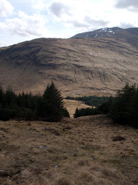
English: Firebreak on SE flank of Meall Odhar Meall Odhar, a 2,150 high hill is now completely encircled by impenetrable forestry and access is not obvious. However, this firebreak provides easy access to the open hillside above the forest. It is located 100 metres from the NW corner of the westmost large field of open pasture near Cononish and identified by a stand of larch at the entrance. The firebreak runs in a NNW'ly direction and rises over a distance of some 300 metres from the 350 metre contour to about the 430 metre contour. View is looking downward with Creag Bhocan seen on the far side of the glen. |
| Date | |
| Source | From geograph.org.uk |
| Author | ronnie leask |
| Attribution (required by the license) | ronnie leask / Firebreak on SE flank of Meall Odhar / |
| Camera location | | View this and other nearby images on: OpenStreetMap |
|---|
_heading:157.00&language=en)
| Object location | | View this and other nearby images on: OpenStreetMap |
|---|
_heading:157.00&language=en)
Licensing
edit

|
This image was taken from the Geograph project collection. See this photograph's page on the Geograph website for the photographer's contact details. The copyright on this image is owned by ronnie leask and is licensed for reuse under the Creative Commons Attribution-ShareAlike 2.0 license.
|
This file is licensed under the Creative Commons Attribution-Share Alike 2.0 Generic license.
Attribution: ronnie leask
- You are free:
- to share – to copy, distribute and transmit the work
- to remix – to adapt the work
- Under the following conditions:
- attribution – You must give appropriate credit, provide a link to the license, and indicate if changes were made. You may do so in any reasonable manner, but not in any way that suggests the licensor endorses you or your use.
- share alike – If you remix, transform, or build upon the material, you must distribute your contributions under the same or compatible license as the original.
File history
Click on a date/time to view the file as it appeared at that time.
| Date/Time | Thumbnail | Dimensions | User | Comment | |
|---|---|---|---|---|---|
| current | 13:08, 26 February 2011 | | 480 × 640 (72 KB) | GeographBot (talk | contribs) | == {{int:filedesc}} == {{Information |description={{en|1=Firebreak on SE flank of Meall Odhar Meall Odhar, a 2,150 high hill is now completely encircled by impenetrable forestry and access is not obvious. However, this firebreak provides easy access to th |
You cannot overwrite this file.
File usage on Commons
There are no pages that use this file.