File:Firenze - mappa rete filoviaria - 1958.svg
(Redirected from File:Firenze mappa rete filoviaria 1958.svg)

Size of this PNG preview of this SVG file: 707 × 600 pixels. Other resolutions: 283 × 240 pixels | 566 × 480 pixels | 905 × 768 pixels | 1,207 × 1,024 pixels | 2,414 × 2,048 pixels | 1,643 × 1,394 pixels.
Original file (SVG file, nominally 1,643 × 1,394 pixels, file size: 8.19 MB)
Captions
Captions
Add a one-line explanation of what this file represents
Summary edit
| Description |
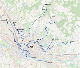
Italiano: Mappa della rete filoviaria di Firenze nel 1958, al momento della soppressione della rete tranviaria. Fonte: Nicola Cefaratti, Moroello Malaspina, 1865-1985. Centoventi anni di trasporti pubblici a Firenze, Calosci - Cortona, 1987, p. 330. |
|||
| Date | (see file history) | |||
| Source | openstreetmap.org | |||
| Creator |
OpenStreetMap contributors |
|||
| Permission (Reusing this file) |
OpenStreetMap data is available under the Open Database License (details). Map tiles are licensed under the Creative Commons Attribution-ShareAlike 2.0 license (CC-BY-SA 2.0).
This file is licensed under the Creative Commons Attribution-Share Alike 2.0 Generic license.
|
|||
| Georeferencing | If inappropriate please set warp_status = skip to hide. |
File history
Click on a date/time to view the file as it appeared at that time.
| Date/Time | Thumbnail | Dimensions | User | Comment | |
|---|---|---|---|---|---|
| current | 21:26, 22 April 2024 | | 1,643 × 1,394 (8.19 MB) | Arbalete (talk | contribs) | Piccola correzione |
| 21:24, 22 April 2024 |  | 1,474 × 1,126 (8.18 MB) | Arbalete (talk | contribs) | Miglioro la grafica | |
| 13:58, 4 October 2013 |  | 1,135 × 980 (3.87 MB) | Arbalete (talk | contribs) | {{Information |Description ={{it|1=Mappa della rete filoviaria di Firenze nel 1958, al momento della soppressione della rete tranviaria.}} |Source ={{own}} |Author =Friedrichstrasse |Date = |Permis... |
You cannot overwrite this file.
File usage on Commons
The following 6 pages use this file:
- User:Arbalete/Maps
- User:Chumwa/OgreBot/Public transport information/2024 April 21-30
- User:Chumwa/OgreBot/Transport Maps/2024 April 21-30
- User:Chumwa/OgreBot/Travel and communication maps/2024 April 21-30
- File:Firenze mappa rete filoviaria 1958.svg (file redirect)
- Category:Trolleybus transport in Florence
File usage on other wikis
The following other wikis use this file:
- Usage on it.wikipedia.org
- Usage on www.wikidata.org