File:Fires in New Mexico, Arizona, and northern Mexico (MODIS 2016-06-27).jpg

Original file (2,200 × 2,800 pixels, file size: 844 KB, MIME type: image/jpeg)
Captions
Captions
Summary
edit.jpg&action=edit§ion=1)
| Description |
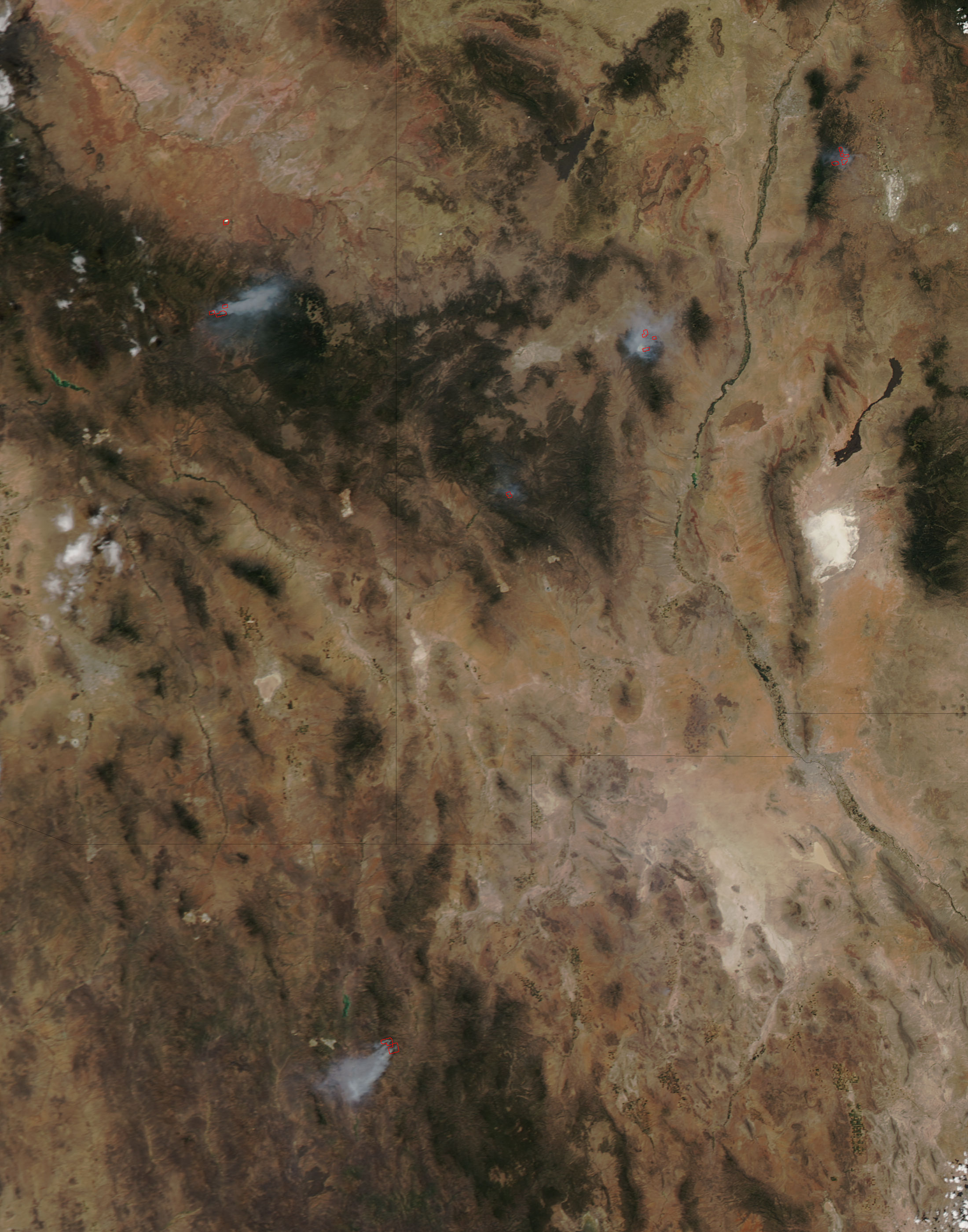
English: Multiple fires burned in New Mexico, Arizona, and northern Mexico in mid-July 2016. The Moderate Resolution Imaging Spectroradiometer (MODIS) onboard NASA's Aqua satellite captured this true-color image on July 18. At least a half-dozen fires and fire complexes (multiple blazes which are close in location and are fought as one blaze) can be seen across the region.
Each red hotspot is an area where the thermal bands on the instrument detected high temperatures. When combined with smoke, as in this image, such hotspots are diagnostic for fire. The Rio Grande River runs from north to south through New Mexico and appears as a curving brownish-green line in the low resolution image. A large fire, the Dog Head Fire, burns in the north and is situation east of the Rio Grande. It has consumed 17,912 acres in the Cibola National Forest region and is 90% contained as of June 26, according to Inciweb. The cause is human activity and is under investigation. The largest fire to the west of the Rio Grande is the North Fire Wildfire burning in the Magdalena Ranger District and has burned 42,107 acres since its ignition by lightning on May 21. As of June 28, this fire is 69% contained. A warm, dry winter followed by a hot spring has increased fire risks throughout the southwestern United States. According to Inciweb on June 26, twenty-nine fires burned in Arizona, with only four of those prescribed burns used to manage land. The other 25 were active wildfires. In New Mexico, six wildfires continued to burn, with the North Fire Wildfire the largest. In addition, Inciweb reported seven active wildfires in Colorado and eleven in California. |
||
| Date | Taken on 18 June 2016 | ||
| Source |
Fires in New Mexico, Arizona, and northern Mexico (direct link)
|
||
| Author | Jeff Schmaltz, MODIS Land Rapid Response Team, NASA GSFC |
| This media is a product of the Aqua mission Credit and attribution belongs to the mission team, if not already specified in the "author" row |
Licensing
edit.jpg&action=edit§ion=2)
| This file is in the public domain in the United States because it was solely created by NASA. NASA copyright policy states that "NASA material is not protected by copyright unless noted". (See Template:PD-USGov, NASA copyright policy page or JPL Image Use Policy.) | ||
 |
Warnings:
|
File history
Click on a date/time to view the file as it appeared at that time.
| Date/Time | Thumbnail | Dimensions | User | Comment | |
|---|---|---|---|---|---|
| current | 19:29, 15 February 2024 | | 2,200 × 2,800 (844 KB) | OptimusPrimeBot (talk | contribs) | #Spacemedia - Upload of http://modis.gsfc.nasa.gov/gallery/images/image06272016_250m.jpg via Commons:Spacemedia |
You cannot overwrite this file.
File usage on Commons
There are no pages that use this file.
.jpg&oldid=852070284)