File:Fires in southern California (afternoon overpass) (MODIS 2017-12-09).jpg

Size of this preview: 471 × 599 pixels. Other resolutions: 188 × 240 pixels | 377 × 480 pixels | 603 × 768 pixels | 804 × 1,024 pixels | 2,200 × 2,800 pixels.
Original file (2,200 × 2,800 pixels, file size: 795 KB, MIME type: image/jpeg)
Captions
Captions
Add a one-line explanation of what this file represents
Summary
edit_(MODIS_2017-12-09).jpg&action=edit§ion=1)
| Description |
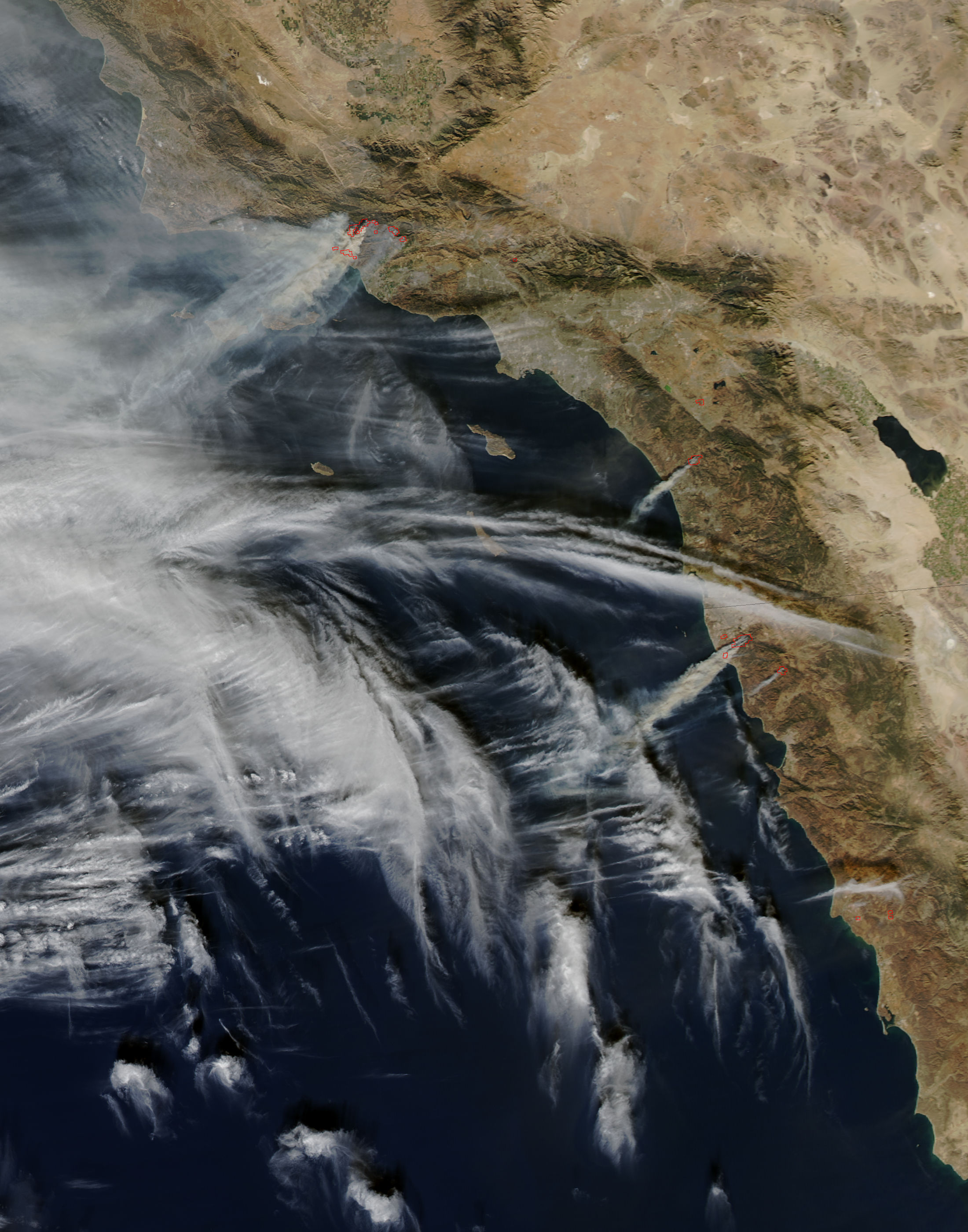
English: Intense wildfires have been scorching several communities in Southern California since early December, 2017. A deadly inferno, the Thomas Fire, ignited on December 6. As of December 8, this single fire consumed 132,000 acres (53,000 hectares or 200 square miles), destroyed 439 structures and damaged 85 more structures. With over 3,500 personnel deployed to fight the fire, containment reached 10% while 15,000 structures remain threatened by the flames. Meanwhile, additional fires to the south, including the Rye, Skirball, and Creek fires in Los Angeles County had charred roughly an additional 20,000 acres combined.
Fierce Santa Ana winds and extremely dry air drove the rapid expansion of the fires, and also made fighting the flames both difficult and dangerous. As of the afternoon of December 8, Cal Fire reported they were managing or assisting with the management of 10 fires across Southern California. On December 7, 2017, the Moderate Resolution Imaging Spectroradiometer (MODIS) aboard NASA’s Aqua satellite acquired a true-color image of intense smoke blowing across the Pacific Ocean from a number of fires in Southern California and also in Mexico. The Thomas Fire sits the furthest to the north. |
||
| Date | Taken on 7 December 2017 | ||
| Source |
Fires in southern California (afternoon overpass) (direct link)
|
||
| Author | Jeff Schmaltz, MODIS Land Rapid Response Team, NASA GSFC |
| This media is a product of the Aqua mission Credit and attribution belongs to the mission team, if not already specified in the "author" row |
Licensing
edit_(MODIS_2017-12-09).jpg&action=edit§ion=2)
| This file is in the public domain in the United States because it was solely created by NASA. NASA copyright policy states that "NASA material is not protected by copyright unless noted". (See Template:PD-USGov, NASA copyright policy page or JPL Image Use Policy.) | ||
 |
Warnings:
|
File history
Click on a date/time to view the file as it appeared at that time.
| Date/Time | Thumbnail | Dimensions | User | Comment | |
|---|---|---|---|---|---|
| current | 17:05, 16 February 2024 | | 2,200 × 2,800 (795 KB) | OptimusPrimeBot (talk | contribs) | #Spacemedia - Upload of http://modis.gsfc.nasa.gov/gallery/images/image12092017_250m.jpg via Commons:Spacemedia |
You cannot overwrite this file.
File usage on Commons
There are no pages that use this file.
_(MODIS_2017-12-09).jpg&oldid=852736145)