File:Fires near Lake Chad (MODIS 2021-10-14).jpg

Original file (2,053 × 1,563 pixels, file size: 372 KB, MIME type: image/jpeg)
Captions
Captions
Summary
edit.jpg&action=edit§ion=1)
| Description |
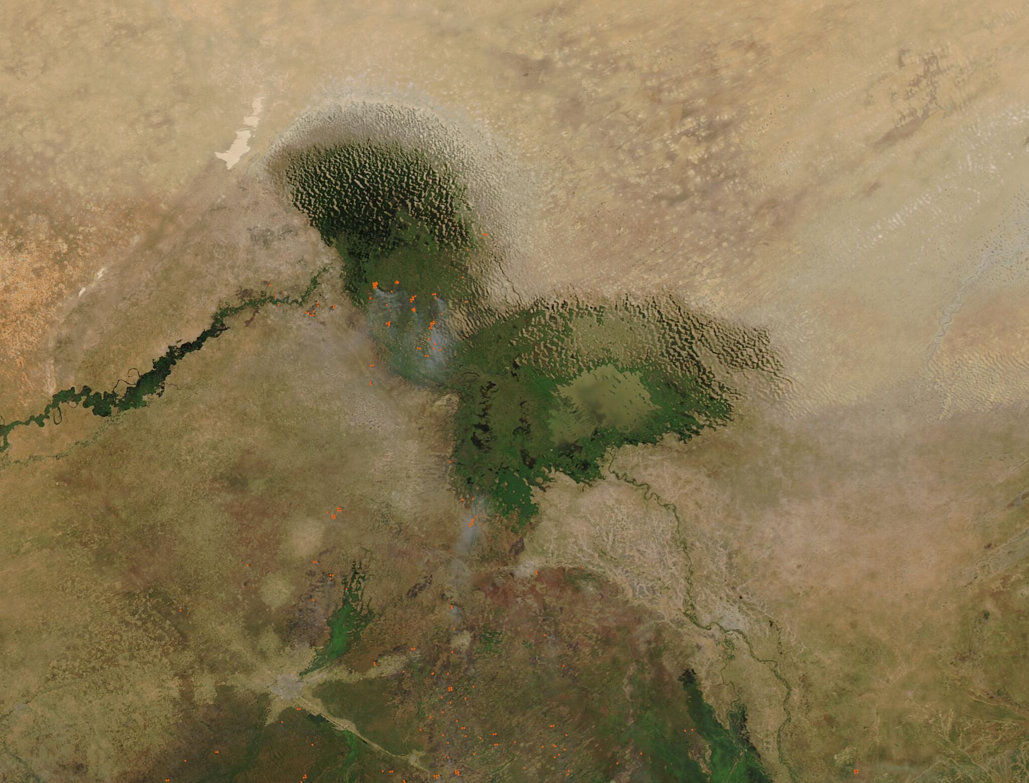
English: Dozens of fires burned in the vegetated areas surrounding Lake Chad in mid-October 2021. The Moderate Resolution Imaging Spectroradiometer (MODIS) on board NASA’s Aqua satellite acquired at true-color image of the scene on October 12. Each red “hot spot” marks an area where the thermal bands on the MODIS instrument detected high temperatures. When combined with typical smoke, such as seen in this image, such hot spots are diagnostic for actively burning fire. The widespread nature, location, and time of year suggest these fires are agricultural in nature.
Located at the intersection of four different countries in the Sahel region of northern sub-Saharan Africa (Chad, Niger, Nigeria, and Cameroon), Lake Chad was once one of the African continent’s largest body of fresh water. An increasingly warm and dry climate, land use change, and poor water management practices, among other factors, have led to substantial shrinkage of the lake. Now a small remnant of its former size, the rapid and dramatic change in Lake Chad has brought substantial political and environmental instability the region. The life of the average resident has changed as well, with most households reporting primary income earned entirely from farming, with only 5% now relying on fishing. Small farms tend to practice traditional methods to manage land, including the use of fire to open new land for crops or pasturage, remove old crops residue from fields, remove wet-season overgrowth from fields, renew pasture, and prepare soil for planting. While individual fires are useful tools, wide-spread fire can negatively impact weather, climate, human and animal health, and natural resources. While light gray smoke rises from many of the hot spots and is undoubtedly responsible for haze hanging over the region, the atmosphere also carries a veil of camel-colored dust, especially in the northern section of the image. This is most likely dust from the Bodele Depression, which is a sand-filled low area north of Lake Chad that provides the source of frequent dust storms in the area. |
||
| Date | Taken on 12 October 2021 | ||
| Source |
Fires near Lake Chad (direct link)
|
||
| Author | MODIS Land Rapid Response Team, NASA GSFC |
| This media is a product of the Aqua mission Credit and attribution belongs to the mission team, if not already specified in the "author" row |
Licensing
edit.jpg&action=edit§ion=2)
| This file is in the public domain in the United States because it was solely created by NASA. NASA copyright policy states that "NASA material is not protected by copyright unless noted". (See Template:PD-USGov, NASA copyright policy page or JPL Image Use Policy.) | ||
 |
Warnings:
|
File history
Click on a date/time to view the file as it appeared at that time.
| Date/Time | Thumbnail | Dimensions | User | Comment | |
|---|---|---|---|---|---|
| current | 18:50, 28 January 2024 | | 2,053 × 1,563 (372 KB) | OptimusPrimeBot (talk | contribs) | #Spacemedia - Upload of http://modis.gsfc.nasa.gov/gallery/images/image10142021_250m.jpg via Commons:Spacemedia |
You cannot overwrite this file.
File usage on Commons
There are no pages that use this file.
.jpg&oldid=846567019)