File:FleurieuPeninsulamap.jpg

Size of this preview: 471 × 599 pixels. Other resolutions: 189 × 240 pixels | 503 × 640 pixels.
Original file (503 × 640 pixels, file size: 191 KB, MIME type: image/jpeg)
Captions
Captions
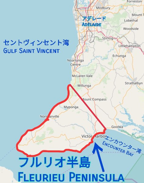
The location of Fleurieu Peninsula
Summary
edit
| Description |
日本語: フルリオ半島の場所を表示
English: Indicating the location of Fleurieu Peninsula |
| Date | |
| Source | https://www.openstreetmap.org/#map=9/-35.3062/138.4717 |
| Author | OpenStreetMap contributors. Modifications by Eddal |
Licensing
edit
This file is licensed under the Creative Commons Attribution-Share Alike 2.0 Generic license.
- You are free:
- to share – to copy, distribute and transmit the work
- to remix – to adapt the work
- Under the following conditions:
- attribution – You must give appropriate credit, provide a link to the license, and indicate if changes were made. You may do so in any reasonable manner, but not in any way that suggests the licensor endorses you or your use.
- share alike – If you remix, transform, or build upon the material, you must distribute your contributions under the same or compatible license as the original.
File history
Click on a date/time to view the file as it appeared at that time.
| Date/Time | Thumbnail | Dimensions | User | Comment | |
|---|---|---|---|---|---|
| current | 09:45, 3 March 2019 | | 503 × 640 (191 KB) | Eddal (talk | contribs) | User created page with UploadWizard |
You cannot overwrite this file.
File usage on Commons
There are no pages that use this file.
File usage on other wikis
The following other wikis use this file:
- Usage on ja.wikipedia.org