File:Flickr - The U.S. Army - Security in PyroKheyl, Afghanistan.jpg

Size of this preview: 800 × 533 pixels. Other resolutions: 320 × 213 pixels | 640 × 427 pixels | 1,024 × 683 pixels | 1,280 × 853 pixels | 2,560 × 1,707 pixels | 5,129 × 3,419 pixels.
Original file (5,129 × 3,419 pixels, file size: 11.32 MB, MIME type: image/jpeg)
Captions
Captions
Add a one-line explanation of what this file represents
Summary
edit
| Description |
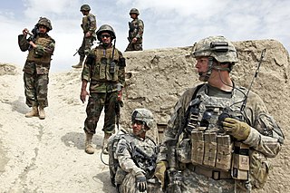
U.S. and Afghan Soldiers determine which route to take to the village of PyroKheyl in Kherwar district in Afghanistan's Logar province, April 8, 2010. The purpose of their mission is to check on conditions and maintain security in the village. The U.S. Soldiers are assigned to Company C, 1st Squadron, 91st Cavalry Regiment, 173rd Airborne Brigade Combat Team. Photo by: Sgt. Russell Gilchrest. |
| Date | |
| Source | Security in PyroKheyl, Afghanistan |
| Author | Sgt Russell Gilchrest/55th Signal Company (Combat Came/U.S. Army |
| Permission (Reusing this file) |
Flinfo has extracted the license below from the metadata of the image (tag "IFD0:Copyright" contained "Public Domain"). The license visible at Flickr was "Attribution License". |
Licensing
edit
This file is a work of a U.S. Army soldier or employee, taken or made as part of that person's official duties. As a work of the U.S. federal government, it is in the public domain in the United States.
|
 |
| This image was originally posted to Flickr by The U.S. Army at https://www.flickr.com/photos/35703177@N00/4525280065. It was reviewed on 2012-11-13 00:57:18 by FlickreviewR, who found it to be licensed under the terms of the cc-by-2.0, which is compatible with the Commons. It is, however, not the same license as given above, and it is unknown whether that license ever was valid. |
File history
Click on a date/time to view the file as it appeared at that time.
| Date/Time | Thumbnail | Dimensions | User | Comment | |
|---|---|---|---|---|---|
| current | 00:28, 13 November 2012 | | 5,129 × 3,419 (11.32 MB) | Matanya (talk | contribs) | == {{int:filedesc}} == {{Information |Description=U.S. and Afghan Soldiers determine which route to take to the village of PyroKheyl in Kherwar district in Afghanistan's Logar province, April 8, 2010. The purpose of their mission is to check on conditi... |
You cannot overwrite this file.
File usage on Commons
There are no pages that use this file.