File:Fliegerhorst Venlo Map 1944.jpg

Size of this preview: 552 × 599 pixels. Other resolutions: 221 × 240 pixels | 442 × 480 pixels | 708 × 768 pixels | 943 × 1,024 pixels | 1,312 × 1,424 pixels.
Original file (1,312 × 1,424 pixels, file size: 659 KB, MIME type: image/jpeg)
Captions
Captions
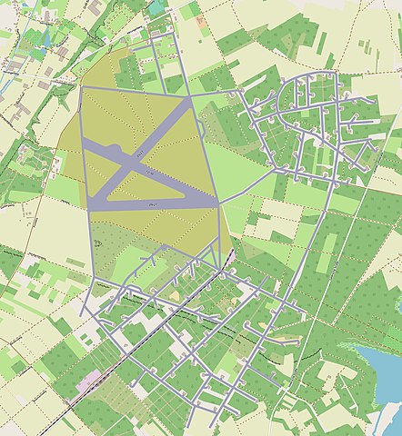
Map of runways and taxiways of Fliegerhorst Venlo around 1944
Summary edit
| Description |
English: Historical map of the Venlo Luftwaffe airfield in World War 2. Also used by the Americans who named it Yankee 55.
Nederlands: Kaart van het Venlose vliegveld van de Luftwaffe in de Tweede Wereldoorlog. |
| Date | |
| Source | Own work |
| Author | Konijnewolf |
| Camera location | | View this and other nearby images on: OpenStreetMap |
|---|
Map made with Openstreetmap software, JOSM, Carto, Qgis, Docker, Gimp.
Licensing edit
I, the copyright holder of this work, hereby publish it under the following license:
This file is licensed under the Creative Commons Attribution-Share Alike 4.0 International license.
- You are free:
- to share – to copy, distribute and transmit the work
- to remix – to adapt the work
- Under the following conditions:
- attribution – You must give appropriate credit, provide a link to the license, and indicate if changes were made. You may do so in any reasonable manner, but not in any way that suggests the licensor endorses you or your use.
- share alike – If you remix, transform, or build upon the material, you must distribute your contributions under the same or compatible license as the original.
File history
Click on a date/time to view the file as it appeared at that time.
| Date/Time | Thumbnail | Dimensions | User | Comment | |
|---|---|---|---|---|---|
| current | 21:29, 23 October 2022 | | 1,312 × 1,424 (659 KB) | Konijnewolf (talk | contribs) | Uploaded own work with UploadWizard |
You cannot overwrite this file.
File usage on Commons
There are no pages that use this file.
File usage on other wikis
The following other wikis use this file:
- Usage on nl.wikipedia.org