File:Flight path after the eruption of Mt Ontake.svg

Size of this PNG preview of this SVG file: 582 × 599 pixels. Other resolutions: 233 × 240 pixels | 466 × 480 pixels | 746 × 768 pixels | 994 × 1,024 pixels | 1,988 × 2,048 pixels | 799 × 823 pixels.
Original file (SVG file, nominally 799 × 823 pixels, file size: 143 KB)
Captions
Captions
Add a one-line explanation of what this file represents
Summary edit
| Description |
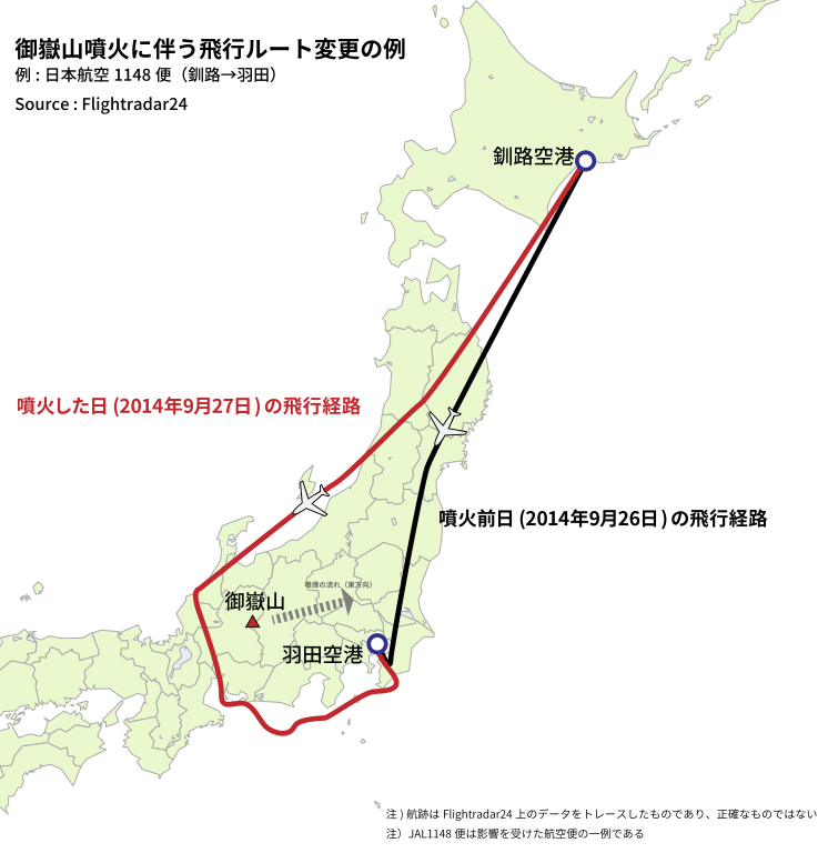
日本語: 御嶽山噴火後の航空便航跡。火山灰が飛散している地域を迂回しているのが確認できる。
Flightradar24を参考に投稿者が航跡をベクターデータ化し、地図(ja:日本地図.svg)と合成した。 (なお、静岡県沖の迂回は御嶽山の影響ではなく、羽田空港混雑の可能性が高い) |
| Date | |
| Source | ja:日本地図.svg |
| Author | ja:user:Lincun |
Licensing edit
This file is licensed under the Creative Commons Attribution-Share Alike 3.0 Unported license.
- You are free:
- to share – to copy, distribute and transmit the work
- to remix – to adapt the work
- Under the following conditions:
- attribution – You must give appropriate credit, provide a link to the license, and indicate if changes were made. You may do so in any reasonable manner, but not in any way that suggests the licensor endorses you or your use.
- share alike – If you remix, transform, or build upon the material, you must distribute your contributions under the same or compatible license as the original.
File history
Click on a date/time to view the file as it appeared at that time.
| Date/Time | Thumbnail | Dimensions | User | Comment | |
|---|---|---|---|---|---|
| current | 14:02, 28 September 2014 | | 799 × 823 (143 KB) | Chihaya Sta (talk | contribs) | User created page with UploadWizard |
You cannot overwrite this file.
File usage on Commons
There are no pages that use this file.
File usage on other wikis
The following other wikis use this file:
- Usage on ja.wikipedia.org
- Usage on zh.wikipedia.org