File:Floeth1.jpg

Size of this preview: 398 × 599 pixels. Other resolutions: 159 × 240 pixels | 319 × 480 pixels | 768 × 1,155 pixels.
Original file (768 × 1,155 pixels, file size: 1.24 MB, MIME type: image/jpeg)
Captions
Captions
Add a one-line explanation of what this file represents
Summary
edit
| Description |
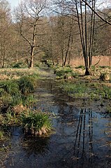
Deutsch: Originalbeschreibung: Flöthbach im Hülser Bruch in Krefeld – Anmerkung: Das kann der Flöthbach sein (dann aber nicht im NSG Hülser Bruch, evtl. LSG Hülser Berg/Hülser Bruch oder NSG Flöthbach?) oder das ist einer der Nebengewässer-Gräben im Hülser Bruch (dann andere Gewässerbezeichnung). |
| Date | |
| Source | Own work |
| Author | Sciarinen |
| Camera location | | View this and other nearby images on: OpenStreetMap |
|---|
Licensing
edit
| I, the copyright holder of this work, release this work into the public domain. This applies worldwide. In some countries this may not be legally possible; if so: I grant anyone the right to use this work for any purpose, without any conditions, unless such conditions are required by law. |
File history
Click on a date/time to view the file as it appeared at that time.
| Date/Time | Thumbnail | Dimensions | User | Comment | |
|---|---|---|---|---|---|
| current | 15:13, 5 April 2007 | | 768 × 1,155 (1.24 MB) | Sciarinen (talk | contribs) | {{Information |Description=Flöthbach im Hülser Bruch in Krefeld |Source=own work |Date= |Author=~~~~ }} |
You cannot overwrite this file.
File usage on Commons
The following 2 pages use this file:
File usage on other wikis
The following other wikis use this file:
- Usage on de.wikipedia.org