File:Flood debris near Llwyn-y-grug - geograph.org.uk - 327922.jpg
No higher resolution available.
Flood_debris_near_Llwyn-y-grug_-_geograph.org.uk_-_327922.jpg (640 × 480 pixels, file size: 155 KB, MIME type: image/jpeg)
Captions
Captions
Add a one-line explanation of what this file represents
Summary
edit
| Description |
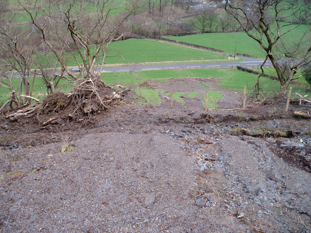
English: Flood debris near Llwyn-y-grug A flood has swept this mass of earth down the course of a small stream - too small to be marked on the 1:50,000 map - descending from Moel Cwm yr Eglwys. It destroyed both the fence just below the footpath, which has evidently been replaced recently, and appears to have been halted by a fence halfway down the field, which has also been buried. The soft, spongy debris also covered the footpath to the left of the picture all the way down to the main road, and was rather difficult to walk through. |
| Date | |
| Source | From geograph.org.uk |
| Author | David Gruar |
| Attribution (required by the license) | David Gruar / Flood debris near Llwyn-y-grug / |
| Camera location | | View this and other nearby images on: OpenStreetMap |
|---|
_heading:45.00&language=en)
| Object location | | View this and other nearby images on: OpenStreetMap |
|---|
_heading:45.00&language=en)
Licensing
edit

|
This image was taken from the Geograph project collection. See this photograph's page on the Geograph website for the photographer's contact details. The copyright on this image is owned by David Gruar and is licensed for reuse under the Creative Commons Attribution-ShareAlike 2.0 license.
|
This file is licensed under the Creative Commons Attribution-Share Alike 2.0 Generic license.
Attribution: David Gruar
- You are free:
- to share – to copy, distribute and transmit the work
- to remix – to adapt the work
- Under the following conditions:
- attribution – You must give appropriate credit, provide a link to the license, and indicate if changes were made. You may do so in any reasonable manner, but not in any way that suggests the licensor endorses you or your use.
- share alike – If you remix, transform, or build upon the material, you must distribute your contributions under the same or compatible license as the original.
- Remove redundant categories and try to put this image in the most specific category/categories
- Remove this template
- The location categories are based on information from this geonames tool and this OpenStreetMap tool combined with a database. You can also have a look at this tool from mysociety.
- The topic category from Geograph was Flood damage (find similar images damage at Geograph)
File history
Click on a date/time to view the file as it appeared at that time.
| Date/Time | Thumbnail | Dimensions | User | Comment | |
|---|---|---|---|---|---|
| current | 18:37, 30 December 2010 | | 640 × 480 (155 KB) | GeographBot (talk | contribs) | == {{int:filedesc}} == {{Information |description={{en|1=Flood debris near Llwyn-y-grug A flood has swept this mass of earth down the course of a small stream - too small to be marked on the 1:50,000 map - descending from Moel Cwm yr Eglwys. It destroyed |
You cannot overwrite this file.
File usage on Commons
There are no pages that use this file.