File:Floods in Kebbi State, Nigeria.jpg

Original file (3,513 × 2,540 pixels, file size: 3.25 MB, MIME type: image/jpeg)
Captions
Captions
Summary edit
| Description |
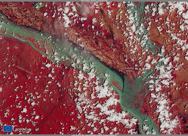
English: Floods have created a humanitarian emergency in Kebbi State, north-eastern Nigeria. During the summer of 2020, Kebbi State was hit by severe weather that caused massive floods which resulted in the destruction of roads and bridges and caused a large amount of fatalities. Farmlands were severely affected: floods washed away at least 8 million tons of rice (about 25% of Nigeria's rice crop), according to estimates by a farmers’ organization. This image, acquired by one of the Copernicus Sentinel-2 satellites on 7 September 2020, shows areas flooded by the Niger and Sokoto Rivers in Kebbi State. High resolution open data from Copernicus Sentinel-2 satellites allow accurate delineation of flood extent and damage assessment. |
| Date | 10 September 2020 (upload date) |
| Source | Floods in Kebbi State, Nigeria |
| Author | European Union , Copernicus Sentinel-2 imagery |
Licensing edit

|
This image contains data from a satellite in the Copernicus Programme, such as Sentinel-1, Sentinel-2 or Sentinel-3. Attribution is required when using this image.
Attribution: Contains modified Copernicus Sentinel data 2020
The use of Copernicus Sentinel Data is regulated under EU law (Commission Delegated Regulation (EU) No 1159/2013 and Regulation (EU) No 377/2014). Relevant excerpts:
Free access shall be given to GMES dedicated data [...] made available through GMES dissemination platforms [...].
Access to GMES dedicated data [...] shall be given for the purpose of the following use in so far as it is lawful:
GMES dedicated data [...] may be used worldwide without limitations in time.
GMES dedicated data and GMES service information are provided to users without any express or implied warranty, including as regards quality and suitability for any purpose. |
File history
Click on a date/time to view the file as it appeared at that time.
| Date/Time | Thumbnail | Dimensions | User | Comment | |
|---|---|---|---|---|---|
| current | 09:57, 31 July 2023 | | 3,513 × 2,540 (3.25 MB) | OptimusPrimeBot (talk | contribs) | #Spacemedia - Upload of https://www.copernicus.eu/system/files/2020-09/image_day/Nigeria_flooding_credit_row.jpg via Commons:Spacemedia |
You cannot overwrite this file.
File usage on Commons
There are no pages that use this file.
File usage on other wikis
The following other wikis use this file:
- Usage on ha.wikipedia.org