File:Floods in New South Wales - Australia.jpg

Original file (4,436 × 2,540 pixels, file size: 10.76 MB, MIME type: image/jpeg)
Captions
Captions
Summary
edit
| Description |
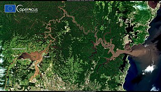
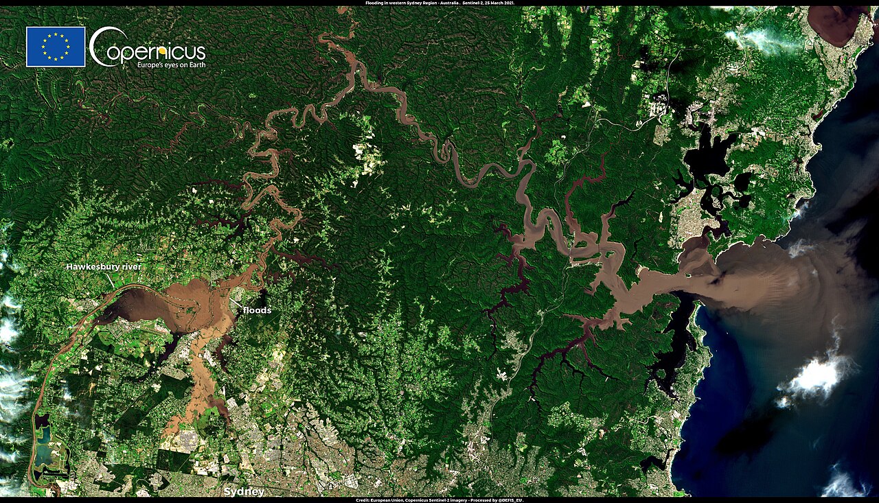
English: This image, acquired by one of the Copernicus Sentinel-2 satellites on 25 March 2021, shows the area north of Sydney, Australia, which remains affected by persistent flooding caused by what experts say was the heaviest rainfall episode in 100 years. The flooding, which began on 19 March, has forced the evacuation of some 35,000 people and caused extensive damage, with houses flooded, roads destroyed, and power lines cut. The Copernicus Emergency Management Service Rapid Mapping component was activated on 20 March (EMSR504) to monitor the floods in 12 areas of interest. When skies are clear, high-resolution open data from the Copernicus Sentinel-2 satellites allow accurate delineation of the extent of flooding and damage assessment. |
| Date | Taken on 25 March 2021 |
| Source | Floods in New South Wales - Australia |
| Author | European Union, Copernicus Sentinel-2 imagery |
Licensing
edit

|
This image contains data from a satellite in the Copernicus Programme, such as Sentinel-1, Sentinel-2 or Sentinel-3. Attribution is required when using this image.
Attribution: Contains modified Copernicus Sentinel data 2021
The use of Copernicus Sentinel Data is regulated under EU law (Commission Delegated Regulation (EU) No 1159/2013 and Regulation (EU) No 377/2014). Relevant excerpts:
Free access shall be given to GMES dedicated data [...] made available through GMES dissemination platforms [...].
Access to GMES dedicated data [...] shall be given for the purpose of the following use in so far as it is lawful:
GMES dedicated data [...] may be used worldwide without limitations in time.
GMES dedicated data and GMES service information are provided to users without any express or implied warranty, including as regards quality and suitability for any purpose. |
File history
Click on a date/time to view the file as it appeared at that time.
| Date/Time | Thumbnail | Dimensions | User | Comment | |
|---|---|---|---|---|---|
| current | 10:32, 27 August 2023 | | 4,436 × 2,540 (10.76 MB) | OptimusPrimeBot (talk | contribs) | #Spacemedia - Upload of https://www.copernicus.eu/system/files/2021-03/image_day/20210325_Australia_floods.jpg via Commons:Spacemedia |
You cannot overwrite this file.
File usage on Commons
There are no pages that use this file.