File:Floods in Thessaly, Greece.jpg

Original file (3,508 × 2,480 pixels, file size: 5.2 MB, MIME type: image/jpeg)
Captions
Captions
Summary edit
| Description |
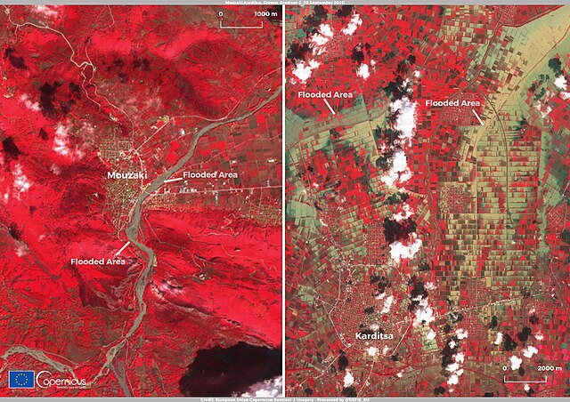
English: The Ianos Mediterranean Hurricane (also known as a Medicane) made landfall in the island of Kefalonia on 18 September 2020, causing flooding, landslides and power cuts, also affecting the islands of Zakynthos and Ithaca and parts of the mainland. The Greek central region of Thessaly has been particularly affected by the storm, with winds of up to 120km/h (75mph) and heavy rainfall that trapped hundreds of people after many streets and houses were flooded. One of the most affected areas is the city of Karditsa, where 3 fatalities were recorded and about 5,000 homes heavily damaged while bridges collapsed and agricultural land turned into mud lakes. In the smaller town of Mouzaki, entire roadways have been flooded, bridges and buildings have collapsed, including the health clinic. Because of these extensive damages, the Copernicus Emergency Management Service has been activated on 19 September (EMSR465) to monitor the flooded areas with delineation maps obtained with high resolution satellite data Service This Sentinel-2 Near InfraRed False Colour image, captured on 20 September 2020, shows two separate views: on the left the town of Mouzaki along the Pamisos river that has caused the collapse of the main bridge and the medical centre. The image on the right shows the city of Karditsa and the surrounding agricultural areas that have been widely flooded. The Copernicus Sentinel-2 mission, composed of two twin satellites (Sentinel-2A and Sentinel-2B) allows to develop applications for flood mapping and damage assessment thanks to its maximum spatial resolution of 10 metres and a maximum revisit time of 5 days. |
| Date | 22 September 2020 (upload date) |
| Source | Floods in Thessaly, Greece |
| Author | European Union , Copernicus Sentinel-2 imagery |
Licensing edit

|
This image contains data from a satellite in the Copernicus Programme, such as Sentinel-1, Sentinel-2 or Sentinel-3. Attribution is required when using this image.
Attribution: Contains modified Copernicus Sentinel data 2020
The use of Copernicus Sentinel Data is regulated under EU law (Commission Delegated Regulation (EU) No 1159/2013 and Regulation (EU) No 377/2014). Relevant excerpts:
Free access shall be given to GMES dedicated data [...] made available through GMES dissemination platforms [...].
Access to GMES dedicated data [...] shall be given for the purpose of the following use in so far as it is lawful:
GMES dedicated data [...] may be used worldwide without limitations in time.
GMES dedicated data and GMES service information are provided to users without any express or implied warranty, including as regards quality and suitability for any purpose. |
File history
Click on a date/time to view the file as it appeared at that time.
| Date/Time | Thumbnail | Dimensions | User | Comment | |
|---|---|---|---|---|---|
| current | 19:35, 31 July 2023 | | 3,508 × 2,480 (5.2 MB) | OptimusPrimeBot (talk | contribs) | #Spacemedia - Upload of https://www.copernicus.eu/system/files/2020-09/image_day/iotd141.jpg via Commons:Spacemedia |
You cannot overwrite this file.
File usage on Commons
There are no pages that use this file.