File:Flurkarte Berthelsdorf 1764.jpg
Size of this preview: 494 × 599 pixels. Other resolutions: 198 × 240 pixels | 396 × 480 pixels | 633 × 768 pixels | 844 × 1,024 pixels | 1,328 × 1,611 pixels.
Original file (1,328 × 1,611 pixels, file size: 499 KB, MIME type: image/jpeg)
Captions
Captions
Add a one-line explanation of what this file represents
Summary
edit
| Description |
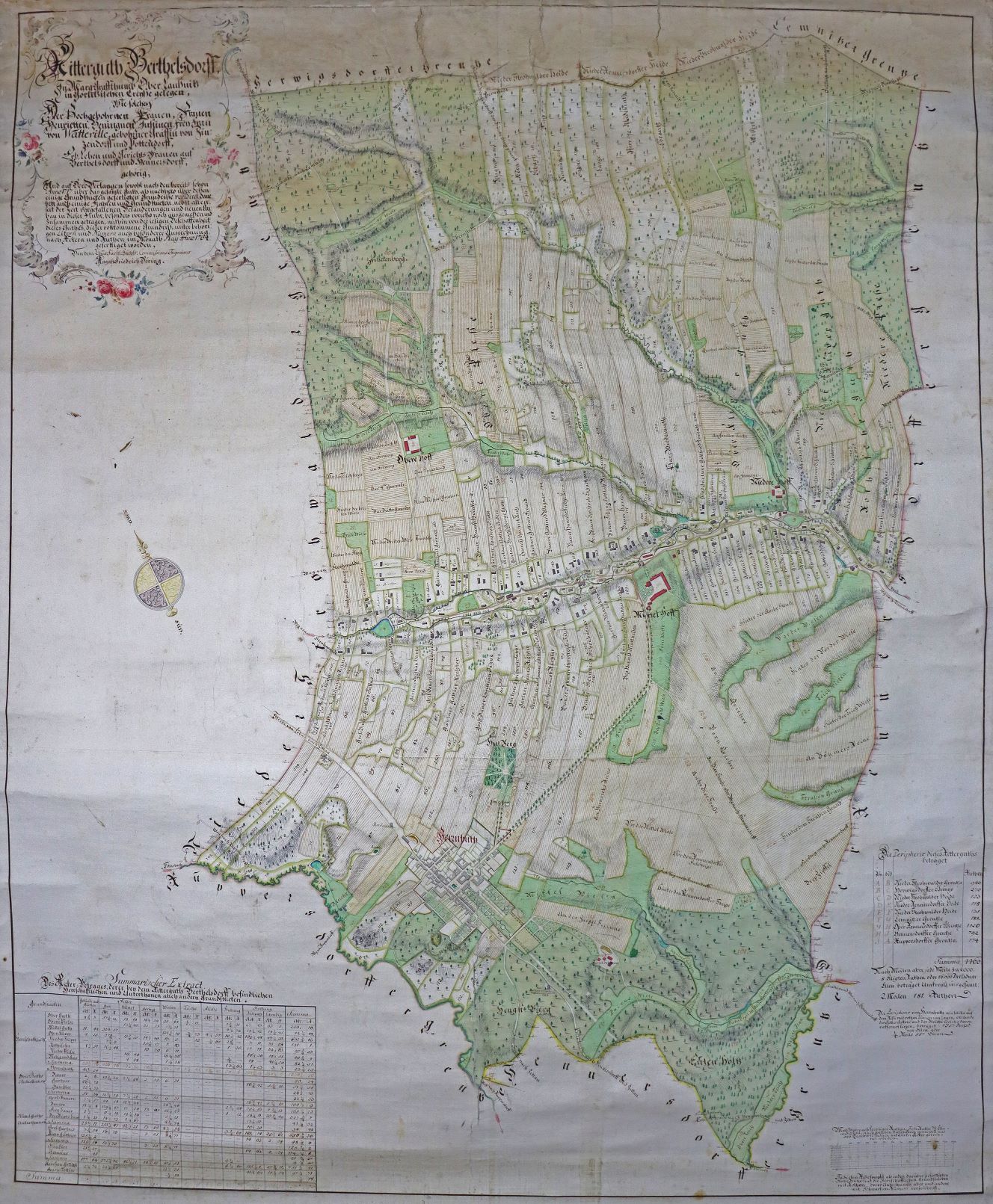
Deutsch: Karte des Rittergutes Berthelsdorf von 1764 |
| Date | |
| Source | Flurkarte von Berthelsdorf aus dem Jahre 1764, Unitätsarchiv Herrnhut: TS.R.34 |
| Author | Sächs. Commisions Ingenieur August Friedrich Döring |
Licensing
edit
This file is licensed under the Creative Commons Attribution-Share Alike 4.0 International license.
- You are free:
- to share – to copy, distribute and transmit the work
- to remix – to adapt the work
- Under the following conditions:
- attribution – You must give appropriate credit, provide a link to the license, and indicate if changes were made. You may do so in any reasonable manner, but not in any way that suggests the licensor endorses you or your use.
- share alike – If you remix, transform, or build upon the material, you must distribute your contributions under the same or compatible license as the original.
File history
Click on a date/time to view the file as it appeared at that time.
| Date/Time | Thumbnail | Dimensions | User | Comment | |
|---|---|---|---|---|---|
| current | 09:19, 17 April 2021 | | 1,328 × 1,611 (499 KB) | Hrohland (talk | contribs) | Uploaded a work by Sächs. Commisions Ingenieur August Friedrich Döring from Flurkarte von Berthelsdorf aus dem Jahre 1764, Unitätsarchiv Herrnhut: TS.R.34 with UploadWizard |
You cannot overwrite this file.
File usage on Commons
The following page uses this file:
File usage on other wikis
The following other wikis use this file:
- Usage on ca.wikipedia.org
- Usage on de.wikipedia.org
- Usage on ro.wikipedia.org
- Usage on tt.wikipedia.org
- Usage on www.wikidata.org