File:Fogo island in Cape Verde - Aerial View from South - September 2022.jpg

Size of this preview: 800 × 450 pixels. Other resolutions: 320 × 180 pixels | 640 × 360 pixels | 1,024 × 576 pixels | 1,280 × 720 pixels | 2,560 × 1,440 pixels | 4,864 × 2,736 pixels.
Original file (4,864 × 2,736 pixels, file size: 11.5 MB, MIME type: image/jpeg)
Captions
Captions
Add a one-line explanation of what this file represents
Summary
edit
| Description |
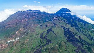
English: Flight São Filipe - Praia, view to the S slopes of the volcanic island of Fogo with the village of Achada Fuma shown on the left side. Lava flows stand in sharp contrast to the otherwise green landscape during the wet season. The former island summit (Monte Amarelo) collapsed into the sea in prehistoric times, leaving behind the escarpment of the Bordeira (upper left portion of the picture). The summit cone Pico do Fogo (2829 m) in the right central background formed afterwards. Credit: Martin Mergili (distributed via imaggeo.egu.eu) |
| Date | |
| Source | https://imaggeo.egu.eu/view/17395/ |
| Author | Martin Mergili (https://imaggeo.egu.eu/user/358/ ) |
| Camera location | | View this and other nearby images on: OpenStreetMap |
|---|
Licensing
edit
This file is licensed under the Creative Commons Attribution 3.0 Unported license.
- You are free:
- to share – to copy, distribute and transmit the work
- to remix – to adapt the work
- Under the following conditions:
- attribution – You must give appropriate credit, provide a link to the license, and indicate if changes were made. You may do so in any reasonable manner, but not in any way that suggests the licensor endorses you or your use.
File history
Click on a date/time to view the file as it appeared at that time.
| Date/Time | Thumbnail | Dimensions | User | Comment | |
|---|---|---|---|---|---|
| current | 14:49, 7 July 2023 | | 4,864 × 2,736 (11.5 MB) | GeoWriter (talk | contribs) | Uploaded a work by Martin Mergili (https://imaggeo.egu.eu/user/358/ ) from https://imaggeo.egu.eu/view/17395/ with UploadWizard |
You cannot overwrite this file.
File usage on Commons
There are no pages that use this file.
File usage on other wikis
The following other wikis use this file:
- Usage on fr.wikipedia.org