File:Forest Way - geograph.org.uk - 1700893.jpg
Forest_Way_-_geograph.org.uk_-_1700893.jpg (640 × 427 pixels, file size: 104 KB, MIME type: image/jpeg)
Captions
Captions
Summary edit
| Description |
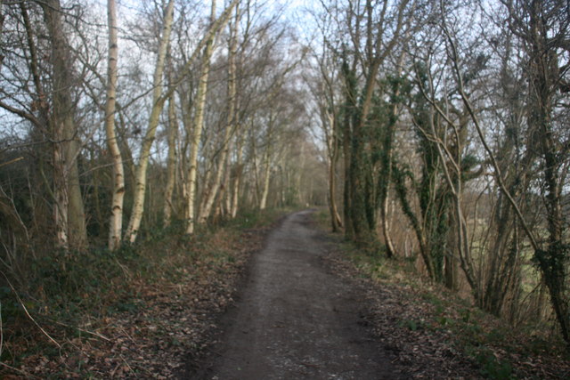
English: Forest Way The Forest Way is situated in the heart of the beautiful East Sussex countryside. It is approximately 10 miles long and is used for walking, cycling, horse riding and the quiet enjoyment of the countryside. It runs from East Grinstead to Groombridge.
The Forest Way runs along an old railway line and is an important habitat for wildlife as a green corridor'. The way lies within the Forest Way Country Park. The Park lies within the High Weald Area of Outstanding Natural Beauty and passes through or close to East Grinstead, Forest Row, Hartfield, Withyham and Groombridge. There are circular trails varying in length and difficulty. Walkers may spot swallows, badger tracks deer and foxes, amongst the fields and woodlands. The way follows the line of the old East grinstead to Groombridge railway. The railway opened in 1866. Although a busy commuter line, it was axed with the Beeching cuts in 1966. Ironically, Dr Beeching lived near Forest Row and regularly travelled up to London on the line when he was Chairman of British Rail. East Sussex County Council bought the line in 1971 and it was designated as a Country Park in 1974. In 2002, following improvements to the surfaced track Forest Way became part of the National Cycle Network. The Park is owned by East Sussex County Council and managed by its Countryside Management Service. The Sussex border path runs along this stretch as well. It is a 150 mile route following the inland border of the county from Thorney Island in West Sussex to Rye in East Sussex. |
| Date | |
| Source | From geograph.org.uk |
| Author | Nigel Chadwick |
| Camera location | | View this and other nearby images on: OpenStreetMap |
|---|
_heading:112.00&language=en)
| Object location | | View this and other nearby images on: OpenStreetMap |
|---|
_heading:112.00&language=en)
Licensing edit

|
This image was taken from the Geograph project collection. See this photograph's page on the Geograph website for the photographer's contact details. The copyright on this image is owned by Nigel Chadwick and is licensed for reuse under the Creative Commons Attribution-ShareAlike 2.0 license.
|
- You are free:
- to share – to copy, distribute and transmit the work
- to remix – to adapt the work
- Under the following conditions:
- attribution – You must give appropriate credit, provide a link to the license, and indicate if changes were made. You may do so in any reasonable manner, but not in any way that suggests the licensor endorses you or your use.
- share alike – If you remix, transform, or build upon the material, you must distribute your contributions under the same or compatible license as the original.
File history
Click on a date/time to view the file as it appeared at that time.
| Date/Time | Thumbnail | Dimensions | User | Comment | |
|---|---|---|---|---|---|
| current | 05:02, 5 March 2011 | | 640 × 427 (104 KB) | GeographBot (talk | contribs) | == {{int:filedesc}} == {{Information |description={{en|1=Forest Way The Forest Way is situated in the heart of the beautiful East Sussex countryside. It is approximately 10 miles long and is used for walking, cycling, horse riding and the quiet enjoyment |
You cannot overwrite this file.
File usage on Commons
There are no pages that use this file.