File:Former cattle enclosure - southern wall - geograph.org.uk - 1101793.jpg
Former_cattle_enclosure_-_southern_wall_-_geograph.org.uk_-_1101793.jpg (640 × 480 pixels, file size: 113 KB, MIME type: image/jpeg)
Captions
Captions
Summary edit
| DescriptionFormer cattle enclosure - southern wall - geograph.org.uk - 1101793.jpg |
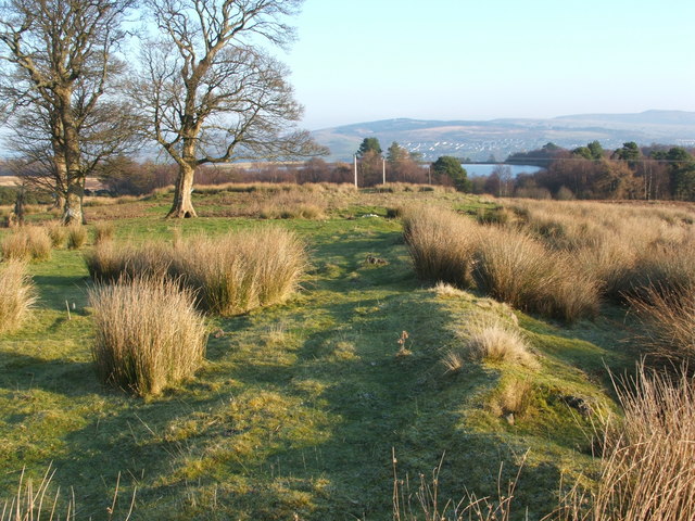
English: Former cattle enclosure - southern wall. Just right of centre is a long straight mound receding into the distance, as shown by the shadow cast by the low winter sun.
This is what remains of the southern wall of an old cattle enclosure near the foot of Carman Hill; it was used as the site of a cattle fair in the late nineteenth century, and it lies at the end of a drove road. In fact, it was the site of the last remnants of the Dumbarton Muir Tryst. The following paragraph gives a summary of the tryst's various locations, and is based on John Mitchell's booklet "The Shielings and Drove Ways of Loch Lomondside" (2000), augmented by additions and corrections provided in the same author's articles "The Great Dumbarton Muir Trust" [in "Scottish Local History", issue 61 (2004)] and "The Legacy of the Highland Drovers" [in issue 76 (2009)]. I have deliberately given only a bare outline of the information here; see the original sources, just cited, for the full details: The Dumbarton Muir Tryst began in 1762 (quite independently of the town's Lammas Cattle Fair, which was held in the Townhead area of Dumbarton, but later moved to the Broadmeadow). The Dumbarton Muir Tryst was, to begin with, held where two drove roads met, at a point between 912926 and the Hill of Standing Stones (see 1009890), but it soon moved to Nobleston Muir (NS4280). According to John Agnew's "The Story of the Vale of Leven", it then moved to the head of the Blairvault Burn (NS4281). Its final site was on Carman Muir, at the site shown in the present photograph; there, the fair faded away in the last decade of the nineteenth century. For the drove road leading here, see: 914922. Carman Reservoir is visible in the background. Previous: 1043828. Next: 1101797. |
| Date | |
| Source | From geograph.org.uk |
| Author | Lairich Rig |
| Camera location | 55° 58′ 20.3″ N, 4° 36′ 36″ W | View this and other nearby images on: OpenStreetMap |
|---|
| Object location | 55° 58′ 20.7″ N, 4° 36′ 35″ W | View this and other nearby images on: OpenStreetMap |
|---|
Licensing edit

|
This image was taken from the Geograph project collection. See this photograph's page on the Geograph website for the photographer's contact details. The copyright on this image is owned by Lairich Rig and is licensed for reuse under the Creative Commons Attribution-ShareAlike 2.0 license.
|
- You are free:
- to share – to copy, distribute and transmit the work
- to remix – to adapt the work
- Under the following conditions:
- attribution – You must give appropriate credit, provide a link to the license, and indicate if changes were made. You may do so in any reasonable manner, but not in any way that suggests the licensor endorses you or your use.
- share alike – If you remix, transform, or build upon the material, you must distribute your contributions under the same or compatible license as the original.
File history
Click on a date/time to view the file as it appeared at that time.
| Date/Time | Thumbnail | Dimensions | User | Comment | |
|---|---|---|---|---|---|
| current | 17:39, 24 February 2011 |  | 640 × 480 (113 KB) | GeographBot (talk | contribs) | == {{int:filedesc}} == {{Information |description={{en|1=Former cattle enclosure - southern wall Just right of centre is a long straight mound receding into the distance, as shown by the shadow cast by the low winter sun. This is what remains of the s |
You cannot overwrite this file.
File usage on Commons
There are no pages that use this file.
Metadata
This file contains additional information such as Exif metadata which may have been added by the digital camera, scanner, or software program used to create or digitize it. If the file has been modified from its original state, some details such as the timestamp may not fully reflect those of the original file. The timestamp is only as accurate as the clock in the camera, and it may be completely wrong.
| _error | 0 |
|---|
