File:Fort Douaumont location map 300px.jpg
No higher resolution available.
Fort_Douaumont_location_map_300px.jpg (300 × 250 pixels, file size: 53 KB, MIME type: image/jpeg)
Captions
Captions
Add a one-line explanation of what this file represents
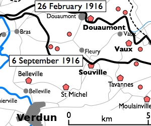
| Description | Basic 300-pixel thumbnail map showing location of Fort Doumont in relation to Verdun and the other forts north and northeast of Verdun. The lines of advance of German forces as at 26 February and 6 September 1916 are shown in black. The River Meuse is shown in blue at left. | ||||||||
| Date | Original version uploaded 16 December 2005. This clip created 11 January 2010. | ||||||||
| Source | Clipped and slightly modified from File:Battle of Verdun map.png by en:User:Gdr. | ||||||||
| Author | en:User:Gdr. | ||||||||
| Permission (Reusing this file) |
|
||||||||
| Other versions |
Derivative works of this file: Défense de Verdun - forts de Vaux et de Douaumont.png |


File history
Click on a date/time to view the file as it appeared at that time.
| Date/Time | Thumbnail | Dimensions | User | Comment | |
|---|---|---|---|---|---|
| current | 16:27, 10 January 2010 | | 300 × 250 (53 KB) | Rcbutcher (talk | contribs) | {{Information |Description=Basic 300-pixel thumbnail map showing location of Fort Doumont in relation to Verdun and the other forts north and northeast of Verdun. The lines of advance of German forces as at 26 February and 6 Septemb |
You cannot overwrite this file.
File usage on Commons
The following page uses this file:
File usage on other wikis
The following other wikis use this file:
- Usage on ca.wikipedia.org
- Usage on en.wikipedia.org
- Usage on tr.wikipedia.org
- Usage on zh.wikipedia.org