File:Fort Duquesne historic marker at Point State Park, Pittsburgh PA (21137589982).jpg

Size of this preview: 800 × 521 pixels. Other resolutions: 320 × 208 pixels | 640 × 417 pixels | 1,024 × 667 pixels | 1,280 × 834 pixels | 2,560 × 1,667 pixels | 5,088 × 3,314 pixels.
Original file (5,088 × 3,314 pixels, file size: 7.81 MB, MIME type: image/jpeg)
Captions
Captions
Add a one-line explanation of what this file represents
Summary edit
.jpg&action=edit§ion=1)
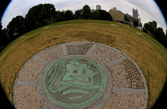
| Description | This location was highly contested during the French and Indian War of 1754-1763. The French built a fort here in 1753, and repulsed a British attack in 1755 (Braddock's Defeat). Eventually the French had to destroy Fort Duquesne to prevent it from falling into English hands; the English and colonials completed the larger Fort Pitt on this location in 1761. |
| Date | |
| Source | Fort Duquesne historic marker at Point State Park, Pittsburgh PA |
| Author | Roy Luck |
| Camera location | | View this and other nearby images on: OpenStreetMap |
|---|
.jpg¶ms=040.441737_N_-080.010938_E_globe:Earth_type:camera_source:Flickr_&language=en)
Licensing edit
.jpg&action=edit§ion=2)
This file is licensed under the Creative Commons Attribution 2.0 Generic license.
- You are free:
- to share – to copy, distribute and transmit the work
- to remix – to adapt the work
- Under the following conditions:
- attribution – You must give appropriate credit, provide a link to the license, and indicate if changes were made. You may do so in any reasonable manner, but not in any way that suggests the licensor endorses you or your use.
| This image was originally posted to Flickr by roy.luck at https://flickr.com/photos/21550937@N03/21137589982. It was reviewed on 2 November 2016 by FlickreviewR and was confirmed to be licensed under the terms of the cc-by-2.0. |
File history
Click on a date/time to view the file as it appeared at that time.
| Date/Time | Thumbnail | Dimensions | User | Comment | |
|---|---|---|---|---|---|
| current | 02:20, 2 November 2016 | | 5,088 × 3,314 (7.81 MB) | Hhm8 (talk | contribs) | Transferred from Flickr via Flickr2Commons |
You cannot overwrite this file.
File usage on Commons
There are no pages that use this file.
.jpg&oldid=866928751)