File:Fort La Latte.jpg
No higher resolution available.
Fort_La_Latte.jpg (730 × 512 pixels, file size: 77 KB, MIME type: image/jpeg)
Captions
Captions
Add a one-line explanation of what this file represents
Summary
edit
| Description |
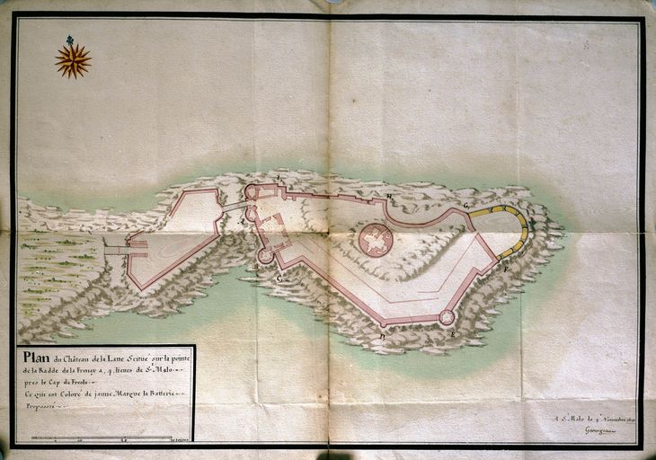
Русский: Карта форта Ла Латте Français : Plan du fort La Latte |
| Date | |
| Source | Plan du fort La Latte, fait à Saint-Malo par Garangeau le 4 novembre 1691 (in fr). Inventaire Général du Patrimoine Culturel. Retrieved on 2020-05-27. |
| Author | Siméon Garangeau (1647—1741) |
Licensing
edit
|
This work is in the public domain in its country of origin and other countries and areas where the copyright term is the author's life plus 100 years or fewer. | |
| This file has been identified as being free of known restrictions under copyright law, including all related and neighboring rights. | |
File history
Click on a date/time to view the file as it appeared at that time.
| Date/Time | Thumbnail | Dimensions | User | Comment | |
|---|---|---|---|---|---|
| current | 18:16, 2 May 2020 | | 730 × 512 (77 KB) | Арсенич (talk | contribs) | {{Изображение | описание = Карта форта Ла Латте, составленная Жаном-Симеоном Гаранжо . 4 ноября 1691 года | источник = http://www.patrimoine.bzh/gertrude-diffusion/illustration/ivr5319832200321pb/f2755a9c-c343-4851-8fd7-d2f529686b70 | время создания = 1691 | автор =Жан-Симеон Гаранжо }} {{PD-old-100}} |
You cannot overwrite this file.
File usage on Commons
There are no pages that use this file.