File:Fours-à-griller--Baillestavy--2.jpg

Original file (4,608 × 3,456 pixels, file size: 6.31 MB, MIME type: image/jpeg)
Captions
Captions
Summary
edit
| Description |
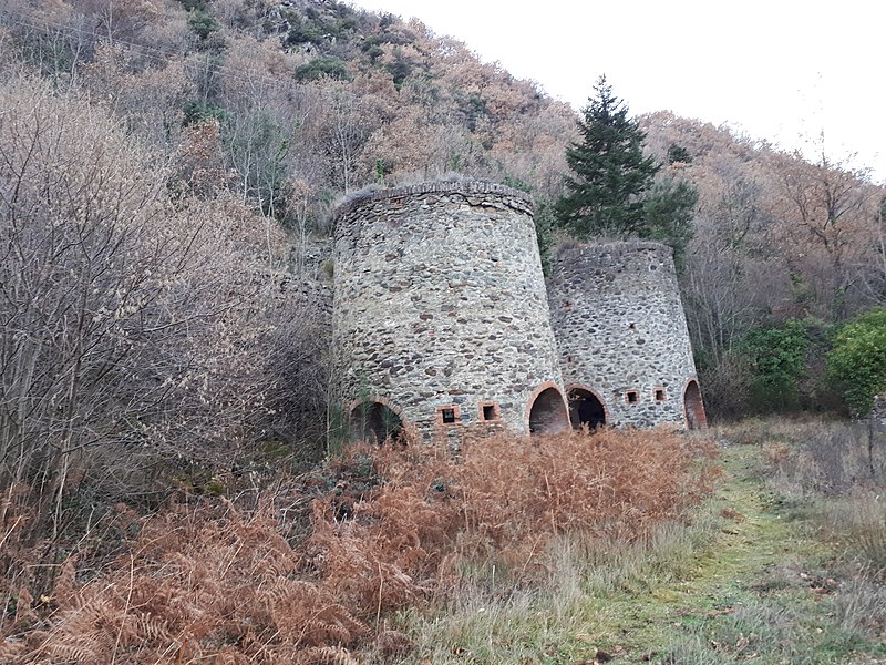
Français : Fours à griller de Rebolledes, commune de Baillestavy, Pyrénées-Orientales (66). Fours à griller de Rebolledes, commune de Baillestavy.
Les fours se trouvent le long de la route qui monte dans la vallée de la Llentilla, entre Baillestavy et Valmanya. Voici un extrait d'un texte explicatif tel qu'il est écrit sur un panneau, sur place : "Ces fours de grillage constituaient un aménagement fondamental de l'exploitation minière qui s'est développée au tout début du XXe siècle, sur les colline de Rebolledes, de l'autre côté de la vallée de la Llentilla. Ils ont été érigés vers 1910 par la Compagnie des mines de fer et de manganèse de Masseguin (Lozère), substituée en 1911 par la compagnie des mines, fonderies et forges d'Alès (Gard). Recevant le minerai à l'aide d'un transporteur aérien long de quelques 250 mètres, ces fours pouvaient grilles une vingtaine de tonnes de minerai carbonaté par jour. Une fois grillé, le minerai était acheminé par charrettes jusqu'à la gare de Vinça, d'où il était expédié vers les hautes-fourneaux du Gard." Voir : https://www.les-pyrenees-orientales.com/Patrimoine/FoursAGrillerDeBaillestavy.phpEnglish: Iron ore reduction furnaces in Rebolledes, municipality of Baillestavy. The ovens are located along the road that climbs into the Llentilla valley, between Baillestavy and Valmanya.
Here is an excerpt from an explanatory text as written on a panel, on the spot: "These roasting furnaces were a fundamental part of the mining operation that developed at the very beginning of the 20th century, on the Rebolledes hills, on the other side of the Llentilla valley. They were built around 1910 by the Compagnie des mines de fer et de manganèse de Masseguin (Lozère), replaced in 1911 by the Compagnie des mines, fonderies et forges d'Alès (Gard). Receiving the ore with the help of an aerial conveyor some 250 metres long, these furnaces could roast some twenty tonnes of carbonated ore per day. Once roasted, the ore was transported by cart to the Vinça railway station, from where it was sent to the high furnaces in the Gard." |
| Date | |
| Source | Own work |
| Author | Alan Mattingly |
| Camera location | | View this and other nearby images on: OpenStreetMap |
|---|
Licensing
edit
- You are free:
- to share – to copy, distribute and transmit the work
- to remix – to adapt the work
- Under the following conditions:
- attribution – You must give appropriate credit, provide a link to the license, and indicate if changes were made. You may do so in any reasonable manner, but not in any way that suggests the licensor endorses you or your use.
- share alike – If you remix, transform, or build upon the material, you must distribute your contributions under the same or compatible license as the original.
File history
Click on a date/time to view the file as it appeared at that time.
| Date/Time | Thumbnail | Dimensions | User | Comment | |
|---|---|---|---|---|---|
| current | 20:49, 29 January 2023 | | 4,608 × 3,456 (6.31 MB) | Alan Mattingly (talk | contribs) | Uploaded own work with UploadWizard |
You cannot overwrite this file.
File usage on Commons
There are no pages that use this file.