File:Foz do Iguaçu (satellite view).jpg

Size of this preview: 800 × 500 pixels. Other resolutions: 320 × 200 pixels | 640 × 400 pixels | 1,024 × 640 pixels | 1,280 × 800 pixels | 2,048 × 1,280 pixels.
Original file (2,048 × 1,280 pixels, file size: 993 KB, MIME type: image/jpeg)
Captions
Captions
Add a one-line explanation of what this file represents
Summary edit
.jpg&action=edit§ion=1)
| Description |
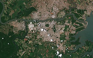
English: Around the city of Foz do Iguaçu in Brazil, Puerto Iguazú in Argentina, Ciudad del Este in Paraguay, as viewed by Hodoyoshi-1 satellite. |
| Date | |
| Source | https://www.axelspace.com/en/hodoyoshi-1-images/foz-do-iguacu-brazil_/ |
| Author | Axelspace Corporation |
| Camera location | | View this and other nearby images on: OpenStreetMap |
|---|
.jpg¶ms=-25.516247_N_-054.585424_E_globe:Earth_type:camera__&language=en)
Licensing edit
.jpg&action=edit§ion=2)
This file is licensed under the Creative Commons Attribution-Share Alike 4.0 International license.
- You are free:
- to share – to copy, distribute and transmit the work
- to remix – to adapt the work
- Under the following conditions:
- attribution – You must give appropriate credit, provide a link to the license, and indicate if changes were made. You may do so in any reasonable manner, but not in any way that suggests the licensor endorses you or your use.
- share alike – If you remix, transform, or build upon the material, you must distribute your contributions under the same or compatible license as the original.
File history
Click on a date/time to view the file as it appeared at that time.
| Date/Time | Thumbnail | Dimensions | User | Comment | |
|---|---|---|---|---|---|
| current | 13:36, 4 February 2019 | | 2,048 × 1,280 (993 KB) | Fukumoto (talk | contribs) | User created page with UploadWizard |
You cannot overwrite this file.
File usage on Commons
The following 3 pages use this file:
File usage on other wikis
The following other wikis use this file:
- Usage on pt.wikipedia.org
.jpg&oldid=744144285)