File:France & Mappemonde - 4 cartes sur la même planche - btv1b53066669x (4 of 5).jpg

Size of this preview: 700 × 600 pixels. Other resolutions: 280 × 240 pixels | 561 × 480 pixels | 897 × 768 pixels | 1,196 × 1,024 pixels | 2,391 × 2,048 pixels | 3,784 × 3,241 pixels.
Original file (3,784 × 3,241 pixels, file size: 2.23 MB, MIME type: image/jpeg)
Captions
Captions
Add a one-line explanation of what this file represents
Summary edit
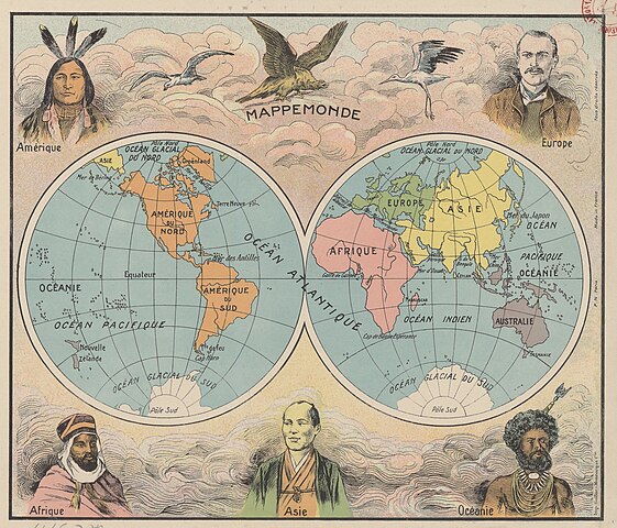
| France & Mappemonde : 4 cartes sur la même planche
( |
|||||||||||||||||||||||||||
|---|---|---|---|---|---|---|---|---|---|---|---|---|---|---|---|---|---|---|---|---|---|---|---|---|---|---|---|
| Title |
France & Mappemonde : 4 cartes sur la même planche |
||||||||||||||||||||||||||
| Description |
Français : Sujet : France
Monde Échelle(s) : [Echelles diverses] Comprend : France physique ; France par départements ; France : chemins de fer, canaux ; Mappemonde Couverture : France Monde Langue : français Éditeur : F[ernand] N[athan] (Paris) |
||||||||||||||||||||||||||
| Date | 1931 | ||||||||||||||||||||||||||
| Dimensions | height: 63 cm (24.8 in); width: 54 cm (21.2 in) | ||||||||||||||||||||||||||
| Collection |
|
||||||||||||||||||||||||||
| References |
Français : Notice du catalogue : http://catalogue.bnf.fr/ark:/12148/cb406897724 |
||||||||||||||||||||||||||
| Source/Photographer |
Français : Bibliothèque nationale de France, département Cartes et plans, GE C-5717
Bibliothèque nationale de France (4/5) |
||||||||||||||||||||||||||
| Permission (Reusing this file) |
|
||||||||||||||||||||||||||

.jpg&action=edit§ion=1)
File history
Click on a date/time to view the file as it appeared at that time.
| Date/Time | Thumbnail | Dimensions | User | Comment | |
|---|---|---|---|---|---|
| current | 13:46, 16 July 2022 | | 3,784 × 3,241 (2.23 MB) | Gzen92Bot (talk | contribs) | Gallica btv1b53066669x |
You cannot overwrite this file.
File usage on Commons
The following page uses this file:
.jpg)
.jpg&oldid=825792210)