File:France 1552 to 1798-de.svg

Size of this PNG preview of this SVG file: 800 × 556 pixels. Other resolutions: 320 × 222 pixels | 640 × 445 pixels | 1,024 × 712 pixels | 1,280 × 890 pixels | 2,560 × 1,779 pixels | 2,584 × 1,796 pixels.
Original file (SVG file, nominally 2,584 × 1,796 pixels, file size: 1.49 MB)
Captions
Captions
Add a one-line explanation of what this file represents
| Description |
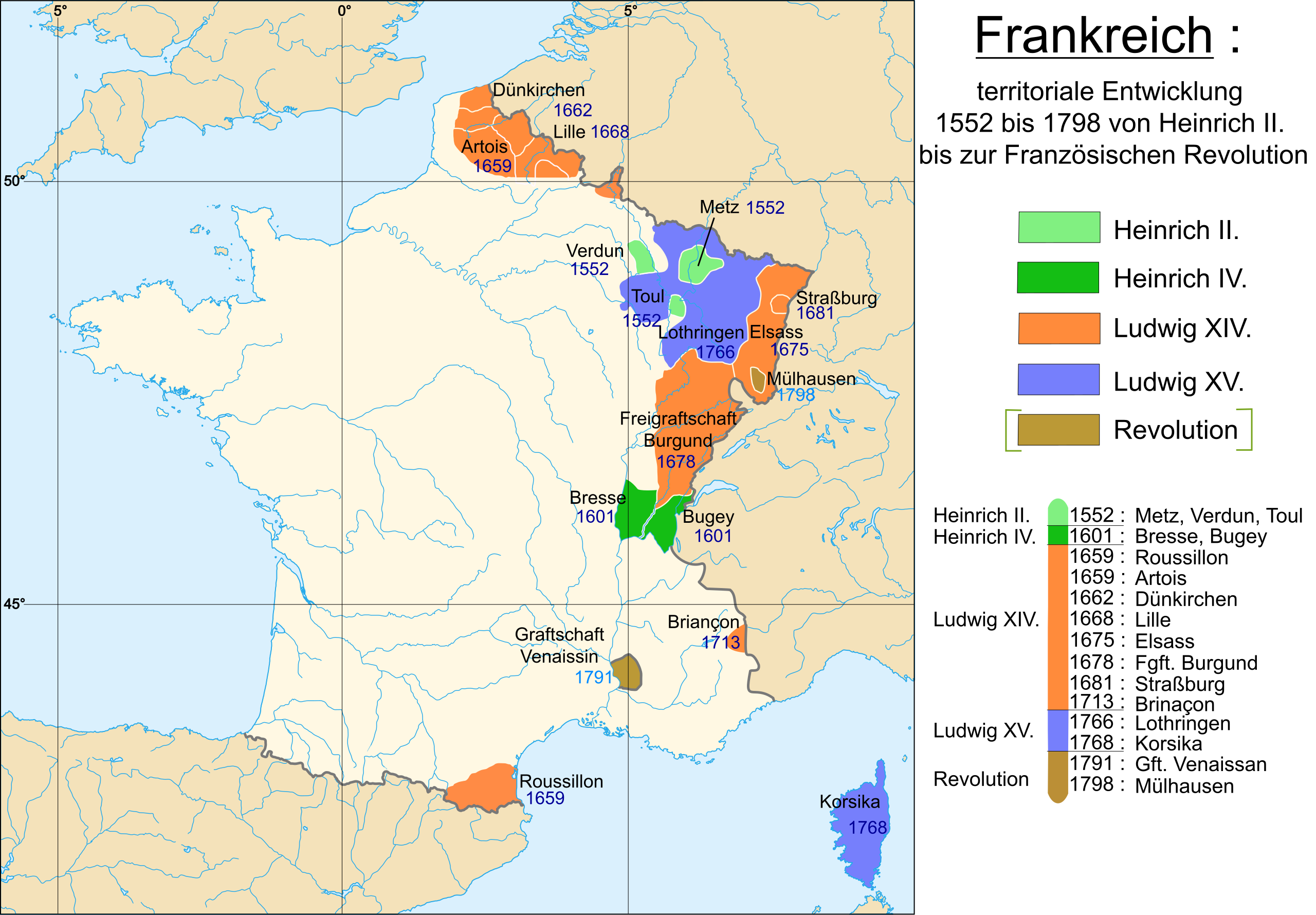
Deutsch: Karte der Expansion Frankreichs zwischen 1552 und 1798 (Heinrich II., Heinrich IV., Ludwig XIV., Ludwig XV., Französische Revolution.)
Français : Carte de la France de 1552 à 1798 (Henri II, Henri IV, Louis XIV, Louis XV, Révolution.) English: Map of France from 1552 to 1798 (Henri II, Henri IV, Louis XIV, Louis XV, Révolution.) 1552 : Die drei Bistümer (de:Bistum Metz, de:Bistum Verdun, de:Bistum Toul). 1559: de:Calais. 1601: de:Bresse, de:Bugey 1659: de:Grafschaft Roussillon 1659: de:Artois 1662: de:Dünkirchen 1668: de:Lille 1675: de:Alsace 1678: de:Freigrafschaft Burgund 1681: de:Straßburg 1713: de:Briançon 1766: de:Herzogtum Lothringen 1768: de:Korsika 1791: de:Grafschaft Venaissin 1798: de:Mülhausen |
| Date | (UTC) |
| Source | |
| Author |
|
| Other versions |
|


| This is a retouched picture, which means that it has been digitally altered from its original version. Modifications: traduction allemand/deutsche Übersetzung. The original can be viewed here: France 1552 to 1798-fr.svg:
|
I, the copyright holder of this work, hereby publish it under the following licenses:
This file is licensed under the Creative Commons Attribution-Share Alike 2.5 Generic, 2.0 Generic and 1.0 Generic license.
- You are free:
- to share – to copy, distribute and transmit the work
- to remix – to adapt the work
- Under the following conditions:
- attribution – You must give appropriate credit, provide a link to the license, and indicate if changes were made. You may do so in any reasonable manner, but not in any way that suggests the licensor endorses you or your use.
- share alike – If you remix, transform, or build upon the material, you must distribute your contributions under the same or compatible license as the original.
| This file is licensed under the Creative Commons Attribution-Share Alike 3.0 Unported license. | ||
| ||
| This licensing tag was added to this file as part of the GFDL licensing update. |

|
Permission is granted to copy, distribute and/or modify this document under the terms of the GNU Free Documentation License, Version 1.2 or any later version published by the Free Software Foundation; with no Invariant Sections, no Front-Cover Texts, and no Back-Cover Texts. A copy of the license is included in the section entitled GNU Free Documentation License. |
You may select the license of your choice.
Original upload log
edit
This image is a derivative work of the following images:
- File:France_1552_to_1798-fr.svg licensed with Cc-by-sa-2.5,2.0,1.0, Cc-by-sa-3.0-migrated, GFDL
- 2010-03-08T08:39:47Z Walké 2584x1796 (889952 Bytes) Correction d'une coquille (comtat), merci à Breogán LIJO pour l'avoir signalé
- 2009-12-14T16:06:48Z Walké 2584x1796 (892707 Bytes) correction de "alscace" vers "alsace" dans la légende
- 2007-11-10T15:43:47Z Walké 2584x1796 (1612160 Bytes) coquille
- 2007-09-12T19:04:03Z Walké 2584x1796 (1608034 Bytes) corse en bleu
- 2007-09-09T10:42:35Z Historicair 2584x1796 (1588962 Bytes)
- 2007-09-09T10:40:03Z Historicair 2584x1796 (1588963 Bytes)
- 2007-09-09T10:24:40Z Walké 2584x1796 (1104236 Bytes) essai en chemin
- 2007-09-09T10:20:23Z Walké 2584x1796 (1090021 Bytes) ...
- 2007-09-09T10:18:17Z Walké 2584x1796 (1090021 Bytes) quelques modifs
- 2007-09-09T10:15:18Z Walké 2584x1796 (1090684 Bytes) corrections
- 2007-09-09T10:07:27Z Walké 2584x1796 (1090621 Bytes) export final ?
- 2007-09-09T09:41:59Z Walké 2584x1796 (1074097 Bytes)
- 2007-09-09T09:39:18Z Walké 2584x1796 (1074039 Bytes) encore un ptit peu
- 2007-09-08T20:25:11Z Walké 2913x1828 (1035979 Bytes) ça avance ...
- 2007-09-08T20:24:50Z Walké 0x0 (688128 Bytes) ça avance ...
- 2007-09-08T18:51:55Z Walké 1864x1838 (1016375 Bytes) {{Information |Description=Carte de la Françe de 1552 à 1798 |Source=Image:France 1552 to 1798-fr.png |Date=08/10/07 |Author= [[User:Walké|Walké]] }}
Uploaded with derivativeFX
File history
Click on a date/time to view the file as it appeared at that time.
| Date/Time | Thumbnail | Dimensions | User | Comment | |
|---|---|---|---|---|---|
| current | 14:43, 5 June 2011 | | 2,584 × 1,796 (1.49 MB) | Furfur (talk | contribs) | {{Information |Description={{de|Karte der Expansion Frankreichs zwischen 1552 und 1798 (Heinrich II., Heinrich IV., Ludwig XIV., Ludwig XV., Französische Revolution.)}} {{fr|Carte de la France de 1552 à 1798 (Henri II, Henri IV, Louis XIV, Louis XV, Ré |
You cannot overwrite this file.
File usage on Commons
The following 4 pages use this file:
File usage on other wikis
The following other wikis use this file:
- Usage on de.wikipedia.org
- Usage on zh.wikipedia.org