File:France Overseas.svg

Size of this PNG preview of this SVG file: 800 × 408 pixels. Other resolutions: 320 × 163 pixels | 640 × 326 pixels | 1,024 × 522 pixels | 1,280 × 653 pixels | 2,560 × 1,305 pixels | 857 × 437 pixels.
Original file (SVG file, nominally 857 × 437 pixels, file size: 1.05 MB)
Captions
Captions
Add a one-line explanation of what this file represents
Summary edit
| Description |
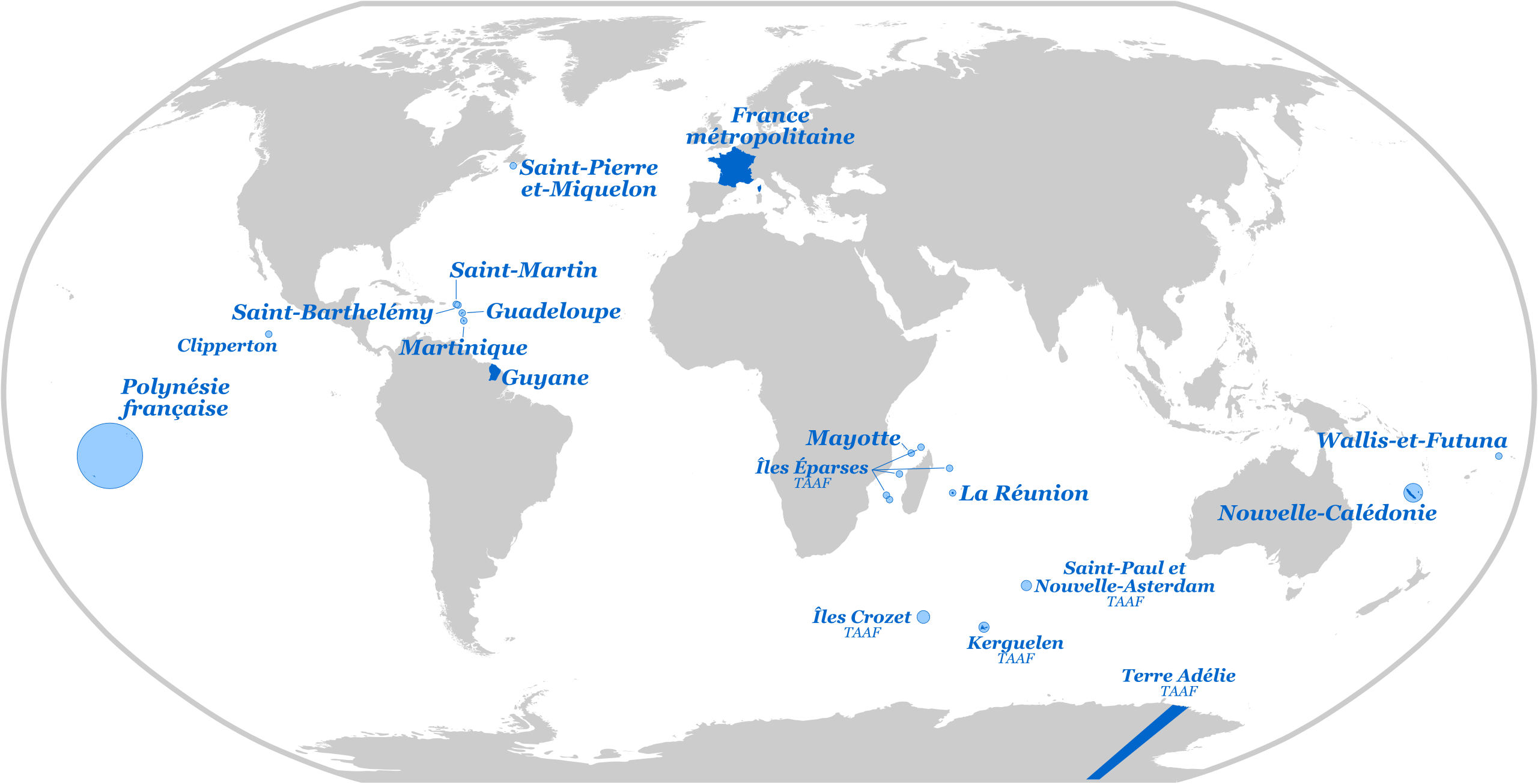
Français : La France avec l'ensemble des territoires d'outre-mer |
| Date | |
| Source |
This file was derived from: Blank Map World Secondary Political Divisions.svg |
| Author | Superbenjamin |
| SVG development |
Licensing edit
I, the copyright holder of this work, hereby publish it under the following license:
This file is licensed under the Creative Commons Attribution-Share Alike 4.0 International license.
- You are free:
- to share – to copy, distribute and transmit the work
- to remix – to adapt the work
- Under the following conditions:
- attribution – You must give appropriate credit, provide a link to the license, and indicate if changes were made. You may do so in any reasonable manner, but not in any way that suggests the licensor endorses you or your use.
- share alike – If you remix, transform, or build upon the material, you must distribute your contributions under the same or compatible license as the original.
File history
Click on a date/time to view the file as it appeared at that time.
| Date/Time | Thumbnail | Dimensions | User | Comment | |
|---|---|---|---|---|---|
| current | 17:48, 4 December 2015 | | 857 × 437 (1.05 MB) | Superbenjamin (talk | contribs) | Meilleure version |
| 19:21, 1 December 2015 |  | 1,066 × 541 (3.66 MB) | Superbenjamin (talk | contribs) | User created page with UploadWizard |
You cannot overwrite this file.
File usage on Commons
More than 100 pages use this file. The following list shows the first 100 pages that use this file only. A full list is available.
- File:Ambiance , faille nord de la Soufrière Guadeloupe.jpg
- File:Anses à la Pointe des Chateaux.jpg
- File:Approche.jpg
- File:Arrivée à la Desirade.jpg
- File:Baie de Cook à Moorea.jpg
- File:Bain à la Cascade aux écrevisses.jpg
- File:Bassin Vital.jpg
- File:Chapelle sur les pentes de la Soufrière.jpg
- File:Cirque de Ciloas.jpg
- File:Concrétions de soufre.jpg
- File:Coraux dans la réserve Cousteau, Plage de Malendure.jpg
- File:Coraux et fonds marins dans la réserve Cousteau, Plage de Malendure.jpg
- File:Coraux et fonds marins à la Réserve Cousteau.jpg
- File:Côte sous le vent, au niveau de la Porte d'Enfer.jpg
- File:Dame tortue sur le Fran Jack en Guadeloupe.jpg
- File:Dans le cirque de Cilaos.jpg
- File:Depuis Grand Anse.jpg
- File:En descendant du Piton des Neiges.jpg
- File:Enclos du Piton de la Fournaise - Ile de la Réunion.jpg
- File:Fakarava.jpg
- File:Fakarava blue lagoon.jpg
- File:Flanc du Piton des Neiges.jpg
- File:Fonds marins, poissons et oursins, à la réserve Cousteau.jpg
- File:Fou a pieds rouges couvant ses oeufs.jpg
- File:GUADELOUPE - ILE DE PETITE TERRE.jpg
- File:GUYANE - Kaw.jpg
- File:Grand Anse point de vue.jpg
- File:Grande Anse.jpg
- File:Guadeloupe - Boeuf sur le chemin de Beautiran.jpg
- File:Guyane - Amana.jpg
- File:Human looking the shark.jpg
- File:La Désirade, depuis Petite-Terre.jpg
- File:La Réunion - Route du Volcan.jpg
- File:La grande faille sur les pentes de la Soufrière.jpg
- File:La raie manta d'iaai.jpg
- File:Lagon de Moorea.jpg
- File:Le lagon d'Ouvéa au coucher du soleil.jpg
- File:Le requin, le roi des océans.jpg
- File:Les coraux de Moorea.jpg
- File:L’invasion des hommes.jpg
- File:Montagne pelé.jpg
- File:Moorea, view from the sky (Motu Fareona).png
- File:Moorea, view from the sky (Motus Tiahura and Fareona).png
- File:Moorea et ses reliefs.jpg
- File:New Caledonia blue lagoon.jpg
- File:New Caledonia lagoon.jpg
- File:Nouvelle-Calédonie Vue du Phare Amédée.jpg
- File:Ouvéa et sa Nurserie.jpg
- File:POLYNESIE - Moorea.jpg
- File:Pain de Sucre aux Saintes.jpg
- File:Palmier bleu de Guadeloupe.jpg
- File:Panoramique du cratère actif et de l'ancien cratère à la Soufrière.jpg
- File:Parc national de La Réunion - Cardinal - Foudia rouge-.jpg
- File:Parc national de la Réunion - Cirque Salazie - Fougère.jpg
- File:Parc national de la Réunion - Fougère parc Bélouve.jpg
- File:Parc national de la Réunion - Lave volcanique.jpg
- File:Passe en "S" 2.jpg
- File:Phare de Petite-Terre.jpg
- File:Piton des Neiges depuis Roche écrite.jpg
- File:Piton des Nuages (Piton des Neiges) La Réunion Parc National.jpg
- File:Pitondelafournaise.jpg
- File:Plage de Grande-Anse, la mangrove.jpg
- File:Plage de Grande Anse, la mangrove et l'océan séparés par la plage.jpg
- File:Plage de Grande Anse après l'averse.jpg
- File:Plage de la Datcha, au Gosier, au coucher du soleil.jpg
- File:Plage du Bourg de Saint-Anne.jpg
- File:Plage du souffleur Port Louis.jpg
- File:Poisson lion en pleine eau en Guadeloupe.jpg
- File:Pont Étang Saint-Paul.jpg
- File:Presqu'île de la caravelle.jpg
- File:Pêcheur au Sud du lagon - Mayotte.jpg
- File:Pêcheurs au Nord du lagon - Mayotte.jpg
- File:Rangiroa lagoon.jpg
- File:Reflets sur le lagon de Moorea d'un coucher de soleil.jpg
- File:Rivierevue.jpg
- File:RivièreBleue.jpg
- File:Rivière Moustique au niveau du Saut des Trois Cornes.jpg
- File:Rivière Moustique en crue à Sofaia.jpg
- File:Récif corallien de Nouvelle-Calédonie.jpg
- File:Réserve de la caravelle.jpg
- File:Sentier dans la forêt tropicale au Saut des Trois Cornes.jpg
- File:Soleilcouche.jpg
- File:Suppression impossible.jpg
- File:Suppression impossible bug interface ?.jpg
- File:Tortue dans la réserve Cousteau, Plage de la Malendure.jpg
- File:Tortue nageant dans les eaux de la Réserve Cousteau.jpg
- File:Tortue verte en Nouvelle-Calédonie.jpg
- File:Un prédateur curieux.jpg
- File:Voh heart New Caledonia.jpg
- File:Vue de la baie des saintes.jpg
- File:Vue depuis le Piton des Neiges.jpg
- File:Vue sur Roche écrite depuis le gite de Bélouve.jpg
- File:Végétation endémique sur les pentes de la Soufrière.jpg
- File:Végétation sur les pentes de la Soufrière.jpg
- File:WALLIS - Faioa.jpg
- File:WALLIS - Nukuhione.jpg
- File:Wallis îlot Faioa.jpg
- File:Zone des éboulis sur les pentes de la Soufrière.jpg
- Template:Photographier les Outre-mer
- Template:Photographier les Outre-mer/en
.png)
.png)
_La_R%C3%A9union_Parc_National.jpg)
View more links to this file.
File usage on other wikis
The following other wikis use this file:
- Usage on ace.wikipedia.org
- Usage on da.wikipedia.org
- Usage on de.wikipedia.org
- Usage on el.wikipedia.org
- Usage on fr.wikipedia.org
- Usage on fr.wikiversity.org
- Usage on hy.wikipedia.org
- Usage on it.wikipedia.org
- Usage on jbo.wikipedia.org
- Usage on kk.wikipedia.org
- Usage on lb.wikipedia.org
- Usage on lij.wikipedia.org
- Usage on sr.wikipedia.org
- Usage on zh-yue.wikipedia.org