File:France map Lambert-93 with regions and departments-occupation evolution.PNG

Size of this preview: 800 × 254 pixels. Other resolutions: 320 × 101 pixels | 640 × 203 pixels | 1,896 × 601 pixels.
Original file (1,896 × 601 pixels, file size: 1.43 MB, MIME type: image/png)
Captions
Captions
Add a one-line explanation of what this file represents
Summary edit
| Description |
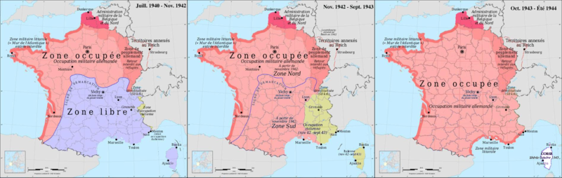
Français : Évolution des zones d'occupation en France durant la seconde guerre mondiale. |
| Date | |
| Source | Own work - basé sur File:France map Lambert-93 with regions and departments-occupation.svg |
| Author | Victor falk |
Licensing edit
I, the copyright holder of this work, hereby publish it under the following license:
This file is licensed under the Creative Commons Attribution-Share Alike 3.0 Unported license.
- You are free:
- to share – to copy, distribute and transmit the work
- to remix – to adapt the work
- Under the following conditions:
- attribution – You must give appropriate credit, provide a link to the license, and indicate if changes were made. You may do so in any reasonable manner, but not in any way that suggests the licensor endorses you or your use.
- share alike – If you remix, transform, or build upon the material, you must distribute your contributions under the same or compatible license as the original.
File history
Click on a date/time to view the file as it appeared at that time.
| Date/Time | Thumbnail | Dimensions | User | Comment | |
|---|---|---|---|---|---|
| current | 14:31, 9 July 2014 | 1,896 × 601 (1.43 MB) | Victor falk~commonswiki (talk | contribs) | Corse libérée en blanc pour ne pas confondre avec la zone libre | |
| 10:35, 7 July 2014 | 1,896 × 601 (1.27 MB) | Victor falk~commonswiki (talk | contribs) | User created page with UploadWizard |
You cannot overwrite this file.
File usage on Commons
There are no pages that use this file.
File usage on other wikis
The following other wikis use this file:
- Usage on en.wikipedia.org
- Usage on fr.wikipedia.org
- Usage on hr.wikipedia.org
- Usage on id.wikipedia.org
- Usage on ml.wikipedia.org
- Usage on pt.wikipedia.org
- Usage on sh.wikipedia.org
- Usage on sl.wikipedia.org
- Usage on uk.wikipedia.org