File:France zonelibre blank.PNG
No higher resolution available.
France_zonelibre_blank.PNG (431 × 413 pixels, file size: 11 KB, MIME type: image/png)
Captions
Captions
Add a one-line explanation of what this file represents
Summary
edit
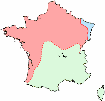
| Description | Map showing German occupied France (red), Vichy France (green), area annexed by Germany (blue), during the Second World War (1940-44) |
| Date | |
| Source | Blank version of french map |
| Author | User:Fabien1309's map |
| Permission (Reusing this file) |
GNU licenced |
| Other versions |
french map spanish map |
Licensing
edit

|
Permission is granted to copy, distribute and/or modify this document under the terms of the GNU Free Documentation License, Version 1.2 or any later version published by the Free Software Foundation; with no Invariant Sections, no Front-Cover Texts, and no Back-Cover Texts. A copy of the license is included in the section entitled GNU Free Documentation License. |
| This file is licensed under the Creative Commons Attribution-Share Alike 3.0 Unported license. | ||
| ||
| This licensing tag was added to this file as part of the GFDL licensing update. |
File history
Click on a date/time to view the file as it appeared at that time.
| Date/Time | Thumbnail | Dimensions | User | Comment | |
|---|---|---|---|---|---|
| current | 15:34, 3 July 2006 | | 431 × 413 (11 KB) | Roke~commonswiki (talk | contribs) | {{Information |Description= Map showing German occupied France (red), Vichy France (green), area annexed by Germany (blue), during the Second World War (1940-44) |Source= Blank version of french map |Date= july 2006 |Author= User:Fabien1309's map | |
You cannot overwrite this file.
File usage on Commons
There are no pages that use this file.
File usage on other wikis
The following other wikis use this file:
- Usage on en.wikipedia.org
- Usage on fr.wikipedia.org
- Usage on id.wikipedia.org