File:Frankfurt Altstadt-Karte-Verlorene Baudenkmaeler 20060307.jpg

Original file (2,048 × 1,487 pixels, file size: 2.39 MB, MIME type: image/jpeg)
Captions
Captions
Summary
edit
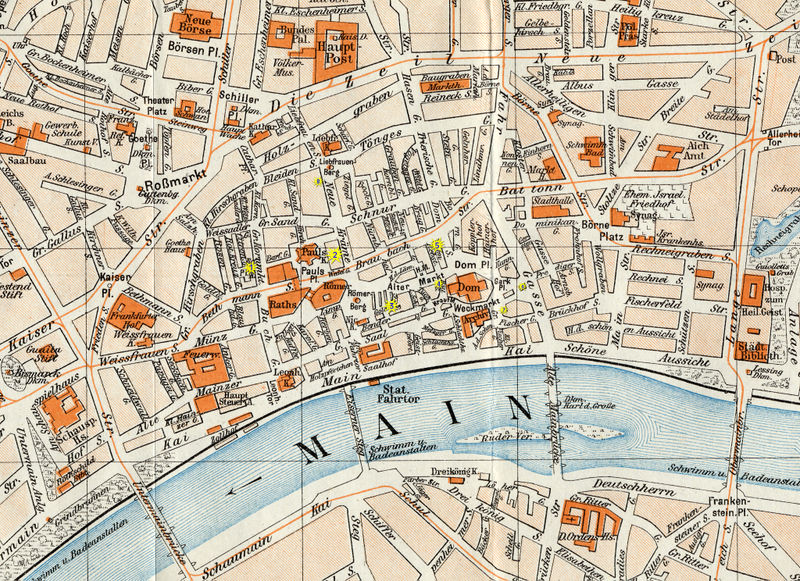
Position verschiedener Baudenkmäler Frankfurter Altstadt, von einem lithografisch hergestellten Stadtplan (Ausschnitt, Maßstab 1:10.000) der Jahrhundertwende - nach Bau der Braubachstraße, also definitiv nach 1908.
Urheberrechtliche Ansprüche dürften aufgrund des Alters erloschen sein.
Legende:
- 1 = Deutsch-reformierte Kirche
- 2 = Alte Börse
- 3 = Fünffingerplätzchen
- 4 = Haus Zur Goldenen Waage
- 5 = Hof Rebstock
- 6 = Haus Fürsteneck
- 7 = Roseneck
- 8 = Alter Braunfels
Hinweis: Diese Karte wurde für den Wikipedia-Artikel "Frankfurt-Altstadt" angefertigt und wird bei Erweiterungen desselbigen von mir ergänzt.
Licensing
edit
|
This work is in the public domain in its country of origin and other countries and areas where the copyright term is the author's life plus 70 years or fewer.
| |
| This file has been identified as being free of known restrictions under copyright law, including all related and neighboring rights. | |
File history
Click on a date/time to view the file as it appeared at that time.
| Date/Time | Thumbnail | Dimensions | User | Comment | |
|---|---|---|---|---|---|
| current | 12:43, 19 March 2006 | | 2,048 × 1,487 (2.39 MB) | Mylius (talk | contribs) | Position verschiedener Baudenkmäler Frankfurter Altstadt, von einem lithografisch hergestellten Stadtplan (Ausschnitt, Maßstab 1:10.000) der Jahrhundertwende - nach Bau der ''Braubachstraße'', also definitiv nach 1908. Urheberrechtliche Ansprüche dü |
| 21:57, 7 March 2006 |  | 2,048 × 1,487 (2.39 MB) | Mylius (talk | contribs) | Position verschiedener Baudenkmäler Frankfurter Altstadt, von einem lithografisch hergestellten Stadtplan (Ausschnitt, Maßstab 1:10.000) der Jahrhundertwende - nach Bau der ''Braubachstraße'', also definitiv nach 1908. Urheberrechtliche Ansprüche dü |
You cannot overwrite this file.
File usage on Commons
The following page uses this file:
File usage on other wikis
The following other wikis use this file:
- Usage on de.wikipedia.org