File:Fredrikshald1660.jpg

Size of this preview: 797 × 600 pixels. Other resolutions: 319 × 240 pixels | 638 × 480 pixels | 1,021 × 768 pixels | 1,280 × 963 pixels | 2,560 × 1,926 pixels | 3,277 × 2,466 pixels.
Original file (3,277 × 2,466 pixels, file size: 1.36 MB, MIME type: image/jpeg)
Captions
Captions
Add a one-line explanation of what this file represents
Summary
edit
| Description |
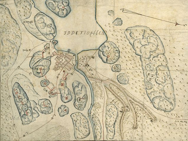
English: Map over the swedish attack by fieldmarshal Lars Kagg on the norwegian town Halden, during the Bjelke Feud 21 january to 23rd february 1660.
Svenska: Bjelkefejden. Karta över svenska arméns attack på Halden i Norge, under befäl av fältmarskalk Lars Kagg den 21 januari - 23 februari 1660.
|
| Date | |
| Source |
Krigsarkivet: Sveriges krig 0425:06:145 https://sok.riksarkivet.se/arkiv/xeMcbgxo8qQGP3SFHyunX3 |
| Author | Isaac Loffman |
Licensing
edit
|
This work is in the public domain in its country of origin and other countries and areas where the copyright term is the author's life plus 100 years or fewer. | |
| This file has been identified as being free of known restrictions under copyright law, including all related and neighboring rights. | |
File history
Click on a date/time to view the file as it appeared at that time.
| Date/Time | Thumbnail | Dimensions | User | Comment | |
|---|---|---|---|---|---|
| current | 20:22, 10 January 2013 | | 3,277 × 2,466 (1.36 MB) | Dagjoh (talk | contribs) | {{Information |Description ={{en|1=Map over the swedish attack by fieldmarshal Lars Kagg on the norwegian town Halden, during the Bjelke Feud 21 january to 23rd february 1660. * A - The fortress Creetzensten, later renamed Fredriksten. From Swedi... |
You cannot overwrite this file.
File usage on Commons
There are no pages that use this file.
File usage on other wikis
The following other wikis use this file:
- Usage on sv.wikipedia.org