File:French Indochina subdivisions.svg

Size of this PNG preview of this SVG file: 393 × 599 pixels. Other resolutions: 157 × 240 pixels | 315 × 480 pixels | 504 × 768 pixels | 671 × 1,024 pixels | 1,343 × 2,048 pixels | 667 × 1,017 pixels.
Original file (SVG file, nominally 667 × 1,017 pixels, file size: 150 KB)
Captions
Captions
Add a one-line explanation of what this file represents

THIS MAP IS SO WRONG AND NO ONE EVEN BOTHERS TO FIX IT. Now it's spread all over the internet, and even poor college professors use it for their lectures and presentations.
Someone please FIX it. Check the boundaries between Tonkin & Annam as well as between Annam & Cochinchina. The damn Vung Tau is being weird too.
Summary
edit
| Description |
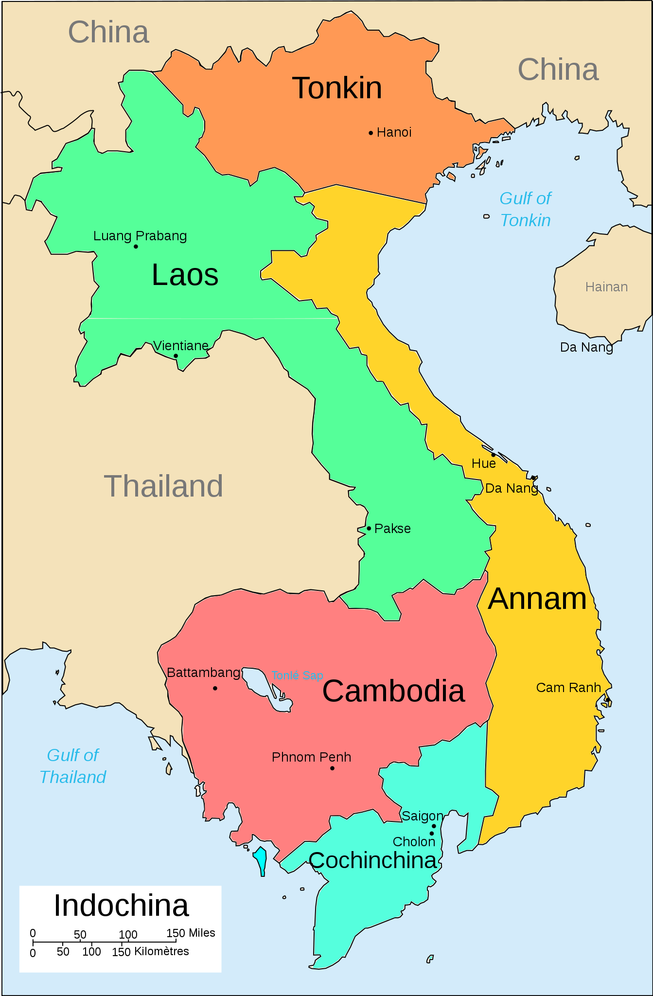
English: A map of the subdivision of the French Indochina federation |
| Date | |
| Source | Own work |
| Author | Bearsmalaysia |
| Other versions |
Српски / srpski: File:French Indochina subdivisions sr.svg |
Licensing
edit
I, the copyright holder of this work, hereby publish it under the following license:
This file is licensed under the Creative Commons Attribution-Share Alike 3.0 Unported license.
- You are free:
- to share – to copy, distribute and transmit the work
- to remix – to adapt the work
- Under the following conditions:
- attribution – You must give appropriate credit, provide a link to the license, and indicate if changes were made. You may do so in any reasonable manner, but not in any way that suggests the licensor endorses you or your use.
- share alike – If you remix, transform, or build upon the material, you must distribute your contributions under the same or compatible license as the original.
File history
Click on a date/time to view the file as it appeared at that time.
| Date/Time | Thumbnail | Dimensions | User | Comment | |
|---|---|---|---|---|---|
| current | 16:36, 3 May 2013 | | 667 × 1,017 (150 KB) | Bearsmalaysia (talk | contribs) | Fixed Tonkin-Annam border for second time |
| 16:23, 3 May 2013 |  | 667 × 1,017 (133 KB) | Bearsmalaysia (talk | contribs) | Adjusted Tonkin-Annam border, coloured Phu Quoc island (part of Cochinchina) and cleaned up some errors | |
| 19:57, 31 March 2013 |  | 667 × 1,017 (135 KB) | Bearsmalaysia (talk | contribs) | oops...the word 'Phnom Penh' duplicated | |
| 19:55, 31 March 2013 |  | 667 × 1,017 (134 KB) | Bearsmalaysia (talk | contribs) | User created page with UploadWizard |
You cannot overwrite this file.
File usage on Commons
The following 5 pages use this file:
File usage on other wikis
The following other wikis use this file:
- Usage on af.wikipedia.org
- Usage on ast.wikipedia.org
- Usage on az.wikipedia.org
- Usage on en.wikipedia.org
- Usage on eo.wikipedia.org
- Usage on gl.wikipedia.org
- Usage on he.wikipedia.org
- Usage on hi.wikipedia.org
- Usage on id.wikipedia.org
- Usage on io.wikipedia.org
- Usage on it.wikipedia.org
- Usage on lt.wikipedia.org
- Usage on lv.wikipedia.org
- Usage on nl.wikipedia.org
- Usage on no.wikipedia.org
- Usage on pl.wikipedia.org
- Usage on sh.wikipedia.org
- Usage on uk.wikipedia.org
- Usage on vi.wikipedia.org
- Usage on www.wikidata.org
- Usage on zh-min-nan.wikipedia.org
- Usage on zh-yue.wikipedia.org
- Usage on zh.wikipedia.org