File:Frisia 600-734-mk.svg

Size of this PNG preview of this SVG file: 338 × 349 pixels. Other resolutions: 232 × 240 pixels | 465 × 480 pixels | 744 × 768 pixels | 992 × 1,024 pixels | 1,983 × 2,048 pixels.
Original file (SVG file, nominally 338 × 349 pixels, file size: 117 KB)
Captions
Captions
Add a one-line explanation of what this file represents
Summary edit
| Description |
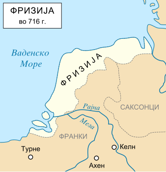
Македонски: Карта на Фризиското кралство.
English: Map of Magna Frisia in Macedonian. |
| Source | |
| Author |
|
| Other versions | file:It Fryske ryk.jpg, File:Frisia 600-734-la.svg |
| This is a retouched picture, which means that it has been digitally altered from its original version. Modifications: Cropped to the low countries area. The original can be viewed here: Frankish Empire 481 to 814-fr.svg:
|
I, the copyright holder of this work, hereby publish it under the following licenses:
This file is licensed under the Creative Commons Attribution-Share Alike 3.0 Unported, 2.5 Generic, 2.0 Generic and 1.0 Generic license.
- You are free:
- to share – to copy, distribute and transmit the work
- to remix – to adapt the work
- Under the following conditions:
- attribution – You must give appropriate credit, provide a link to the license, and indicate if changes were made. You may do so in any reasonable manner, but not in any way that suggests the licensor endorses you or your use.
- share alike – If you remix, transform, or build upon the material, you must distribute your contributions under the same or compatible license as the original.

|
Permission is granted to copy, distribute and/or modify this document under the terms of the GNU Free Documentation License, Version 1.2 or any later version published by the Free Software Foundation; with no Invariant Sections, no Front-Cover Texts, and no Back-Cover Texts. A copy of the license is included in the section entitled GNU Free Documentation License. |
You may select the license of your choice.
Original upload log edit
This image is a derivative work of the following images:
- File:Frankish_Empire_481_to_814-fr.svg licensed with Cc-by-sa-3.0,2.5,2.0,1.0, GFDL
- 2008-03-06T15:22:04Z Eric.dane 1735x1227 (340483 Bytes) réordonnacement de la légende, repositionnement de labels
- 2007-10-15T14:19:38Z Sémhur 1735x1227 (338813 Bytes) Correction de fautes d'orthographe
- 2007-10-14T19:51:47Z Sémhur 1735x1227 (338789 Bytes) Et encore le bitmap...
- 2007-10-14T19:49:59Z Sémhur 1735x1227 (339187 Bytes) {{Information |Description=Carte en français de l'expansion de l'empire Franc, entre 481 et 814. |Source=travail personnel, d'après [[:Image:Frankish empire.jpg]]. |Date=2007-10-14 |Author= [[User:Sémhur|Sémhur]] ·[
Uploaded with derivativeFX
File history
Click on a date/time to view the file as it appeared at that time.
| Date/Time | Thumbnail | Dimensions | User | Comment | |
|---|---|---|---|---|---|
| current | 07:26, 9 April 2013 | | 338 × 349 (117 KB) | Bjankuloski06en (talk | contribs) | Correct rendering of names. |
| 23:22, 22 November 2012 |  | 338 × 349 (77 KB) | Bjankuloski06en (talk | contribs) | Visual improvement and correcting some words. | |
| 22:51, 2 September 2010 |  | 338 × 349 (40 KB) | MacedonianBoy (talk | contribs) | {{Information |Description={{en|1=Map of Magna Frisia in Macedonian.}} {{mk|1=Карта на Фризиското Кралство на македонски.}} |Source={{own}} |Author=MacedonianBoy |Date= |Permission= |other_versio |
You cannot overwrite this file.
File usage on Commons
There are no pages that use this file.
File usage on other wikis
The following other wikis use this file:
- Usage on mk.wikipedia.org