File:Fujian quan tu LOC 96685903.jpg

Size of this preview: 655 × 599 pixels. Other resolutions: 262 × 240 pixels | 525 × 480 pixels | 840 × 768 pixels | 1,120 × 1,024 pixels | 2,239 × 2,048 pixels | 9,358 × 8,560 pixels.
Original file (9,358 × 8,560 pixels, file size: 8.93 MB, MIME type: image/jpeg)
Captions
Captions
Add a one-line explanation of what this file represents
Summary edit
| Warning | The original file is very high-resolution. It might not load properly or could cause your browser to freeze when opened at full size. |
|---|
| Description |
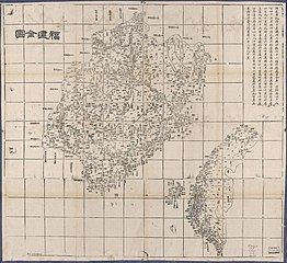
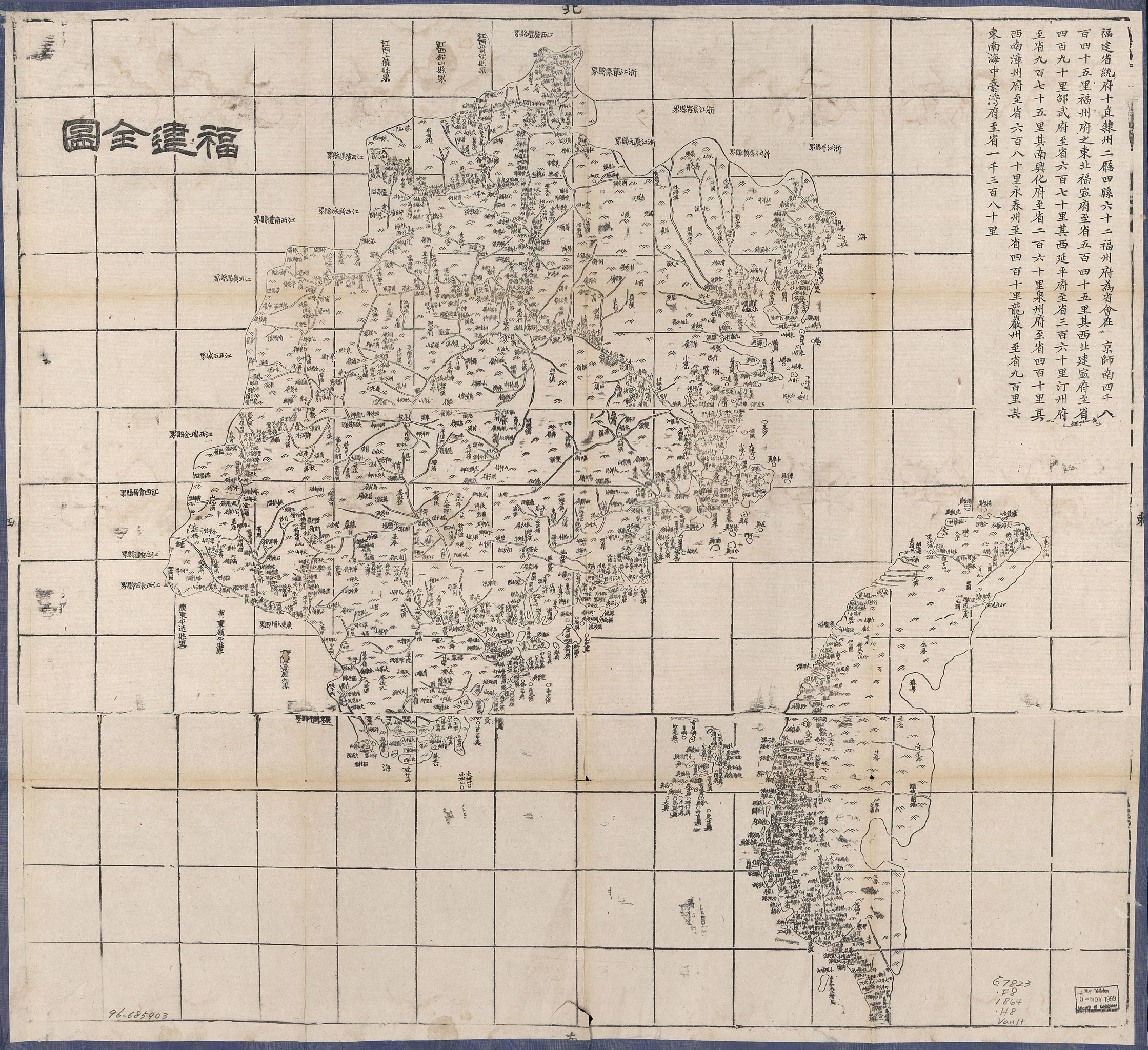
English: Map of the Fujian Province of the Qing Empire at c. 1:1,000,000 scale. Shows the areas of the modern territories of Fujian and Taiwan. Wood block print. Relief shown pictorially. One of the 26 maps compiled by the Hubei Province official press as the Daqing Yitong Yudi Quantu atlas in 1864. Text includes route distance information. LOC copy with some damage. Title also on verso.
中文:福建全圖, 福建全图, Fujian Quantu, Fu-chien Ch'üan-t'u. 大清帝国福建省地图,现在福建与台湾. |
||
| Title | English: Complete Map of Fujian
中文:福建全圖, Fujian Quantu |
||
| Shelf ID | G7823.F8 1864 .H8 | ||
| Date |
English: 1864
中文:同治3年 |
||
| Source | LOC | ||
| Author |
English: Hubei Official Press
中文:湖北官书局, Hubei Guanshuju |
||
| Permission (Reusing this file) |
|
||
| Other versions |
|
||
| Location | Fujian Sheng · China · Taiwan | ||
| Part of | American Memory · General Maps · Catalog · Geography And Map Division | ||
| Subject | Fujian Sheng (China) · Maps · Fujian Sheng · China · Administrative And Political Divisions · Taiwan |


.jpg)
Licensing edit
|
This is a faithful photographic reproduction of a two-dimensional, public domain work of art. The work of art itself is in the public domain for the following reason:
The official position taken by the Wikimedia Foundation is that "faithful reproductions of two-dimensional public domain works of art are public domain".
This photographic reproduction is therefore also considered to be in the public domain in the United States. In other jurisdictions, re-use of this content may be restricted; see Reuse of PD-Art photographs for details. | ||||
File history
Click on a date/time to view the file as it appeared at that time.
| Date/Time | Thumbnail | Dimensions | User | Comment | |
|---|---|---|---|---|---|
| current | 05:12, 11 May 2018 | | 9,358 × 8,560 (8.93 MB) | Fæ (talk | contribs) | LOC Maps https://www.loc.gov/item/96685903/ #8384 |
You cannot overwrite this file.
File usage on Commons
The following 2 pages use this file:
File usage on other wikis
The following other wikis use this file:
- Usage on de.wikipedia.org
- Usage on en.wikipedia.org
- Usage on fr.wikipedia.org
- Usage on ja.wikipedia.org
- Usage on vi.wikipedia.org
- Usage on zh.wikipedia.org