File:Fujisawa town Okago elementary school Aerial view (1977-11).jpg
No higher resolution available.
Fujisawa_town_Okago_elementary_school_Aerial_view_(1977-11).jpg (540 × 360 pixels, file size: 162 KB, MIME type: image/jpeg)
Captions
Captions
Add a one-line explanation of what this file represents
Summary
edit.jpg&action=edit§ion=1)
| Description |
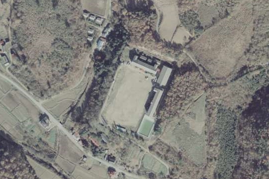
日本語: 藤沢町立大籠小学校(2009年閉校)の空中写真。大籠字鈴ケ沢に校舎を構えていた時代のもので、跡地は原野と化している。校舎左上には教員住宅がある。1977年11月撮影の空中写真「CTO779-C13-15」を加工して作成。 |
| Date | |
| Source | https://mapps.gsi.go.jp/maplibSearch.do?specificationId=688310 |
| Author | 国土地理院 |
Licensing
edit.jpg&action=edit§ion=2)

|
The copyright holder of this file, the Ministry of Land, Infrastructure, Transport and Tourism of Japan, allows anyone to use it for any purpose, provided that the copyright holder is properly attributed. Redistribution, derivative work, commercial use, and all other use is permitted. |
Attribution:
Copyright © National Land Image Information (Color Aerial Photographs), Ministry of Land, Infrastructure, Transport and Tourism
|
 |
This image is copyrighted by the Ministry of Land, Infrastructure, Transport and Tourism of Japan. For terms of use, see the stipulation to use of National Land Information (in Japanese) and message from MLIT (in Japanese and English). When you display this image on an article, include the following phrase in the description: "Made based on National Land Image Information (Color Aerial Photographs), Ministry of Land, Infrastructure, Transport and Tourism".
|
File history
Click on a date/time to view the file as it appeared at that time.
| Date/Time | Thumbnail | Dimensions | User | Comment | |
|---|---|---|---|---|---|
| current | 16:50, 11 November 2023 | | 540 × 360 (162 KB) | とらもん192 (talk | contribs) | Uploaded a work by 国土地理院 from https://mapps.gsi.go.jp/maplibSearch.do?specificationId=688310 with UploadWizard |
You cannot overwrite this file.
File usage on Commons
There are no pages that use this file.
File usage on other wikis
The following other wikis use this file:
- Usage on ja.wikipedia.org
.jpg&oldid=821382342)