File:Fukushima I nuclear accidents radioactive cloud-en.svg

Original file (SVG file, nominally 511 × 183 pixels, file size: 2.86 MB)
Captions
Captions
Summary
edit
| Description |
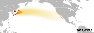
The Fukushima accident's radioactive plume. The map displays areas which have been overflown by the plume. Made by the Graphic Lab/Map workshop's wikigraphists (WP:GL/MAP) Sources 2011/03/18:
Note: Aeronobie.be now ask to cite and follow the Zamg.ac.at's page (currently the main source), stating: '--Varlaam 21:19, 24 March 2011 (UTC)'"The World Meteorological Organisation asked the Central Institute for Meteorology and Geodynamics (or ZAMG, Austria) to support the International Atomic Energy Agency by providing the atmospheric plume calculations." Background based on: A blank map of the world centred at the 180E longitude line. Detailed SVG map with grouping enabled to connect all non-contiguous parts of a country's territory for easy colouring. Smaller countries can also be represented by larger circles to show their data easier. A thorough description of use and other instructions relating to can be found on the instruction page |
||
| Date | (UTC) | ||
| Source | Own work based on: BlankMap-World-180E.svg | ||
| Author | BlankMap-World-180E.svg: Lokal_Profil / derivative work: Yug | ||
| SVG development |
|
Licensing
edit
| I, the copyright holder of this work, release this work into the public domain. This applies worldwide. In some countries this may not be legally possible; if so: I grant anyone the right to use this work for any purpose, without any conditions, unless such conditions are required by law. |
Original upload log
edit
This image is a derivative work of the following images:
- File:BlankMap-World-180E.svg licensed with PD-self
- 2008-04-13T22:24:07Z Lokal_Profil 940x477 (3620359 Bytes) {{Information |Description=A blank map of the world centered at the 180E longitude line. Detailed SVG map with grouping enabled to connect all non-contiguous parts of a country's territory for easy colouring. Smaller count
Uploaded with derivativeFX
File history
Click on a date/time to view the file as it appeared at that time.
| Date/Time | Thumbnail | Dimensions | User | Comment | |
|---|---|---|---|---|---|
| current | 15:06, 18 March 2011 | 511 × 183 (2.86 MB) | Yug (talk | contribs) | reduction of the area, the source go forward USA-Mexico, but don't reach them by 03/20. | |
| 13:18, 18 March 2011 | 511 × 183 (2.86 MB) | Yug (talk | contribs) | fix famous "black square bug" ;) | ||
| 13:06, 18 March 2011 | 511 × 183 (2.86 MB) | Yug (talk | contribs) | {{Information |Description=Fukushima accident's radioactive cloud. Made by the Graphic Lab/Map workshop's wikigraphists ([[:en:WP:GL/MAP) Sources 2011/03/18: * {{cite web|title=Nouvelle simulation du |
You cannot overwrite this file.
File usage on Commons
There are no pages that use this file.
File usage on other wikis
The following other wikis use this file:
- Usage on ca.wikipedia.org
- Usage on de.wikipedia.org
- Usage on de.wikinews.org
- Usage on en.wikipedia.org
- Usage on fr.wikipedia.org
- Usage on sh.wikipedia.org
- Usage on sr.wikipedia.org
- Usage on uk.wikipedia.org